By Township Canada
Energy API Collection Docs, Agriculture Drought Fix, and All 8 API Products in Onboarding
The Energy API docs now cover collection and cross-parcel endpoints, the agriculture report returns drought data for direct quarter-section inputs, and the API onboarding wizard shows all 8 products.
Three changes shipped this week that affect API developers and Agriculture Bundle subscribers. The Energy API documentation now covers the collection and cross-parcel endpoints that were previously undocumented. The agriculture parcel report returns drought data for direct quarter-section inputs, fixing a path that was silently skipped. And the API onboarding wizard shows all eight Township Canada API products instead of four.
None of these are new capabilities. The endpoints existed, the drought data was there, and the products were available. What changed is that developers can now find them.
Energy API: collection and cross-parcel endpoints documented
The Energy API launched with documentation for the single-parcel report endpoint, /energy/report, which returns the full energy report for one LSD. That endpoint is still the starting point for most integrations: give it a legal land description, get back wells, pipelines, facilities, tenure, production, and alternative energy data in one response.
What the docs did not cover were the collection endpoints that developers need when they are working at fleet scale. An operator managing 400 wells across a disposition area does not want to call /energy/report 400 times and parse the wells section from each response. They can request a paginated well list for each LSD, filtered by status and sorted by depth. Cross-parcel operator endpoints provide a separate route for operator-wide screening.
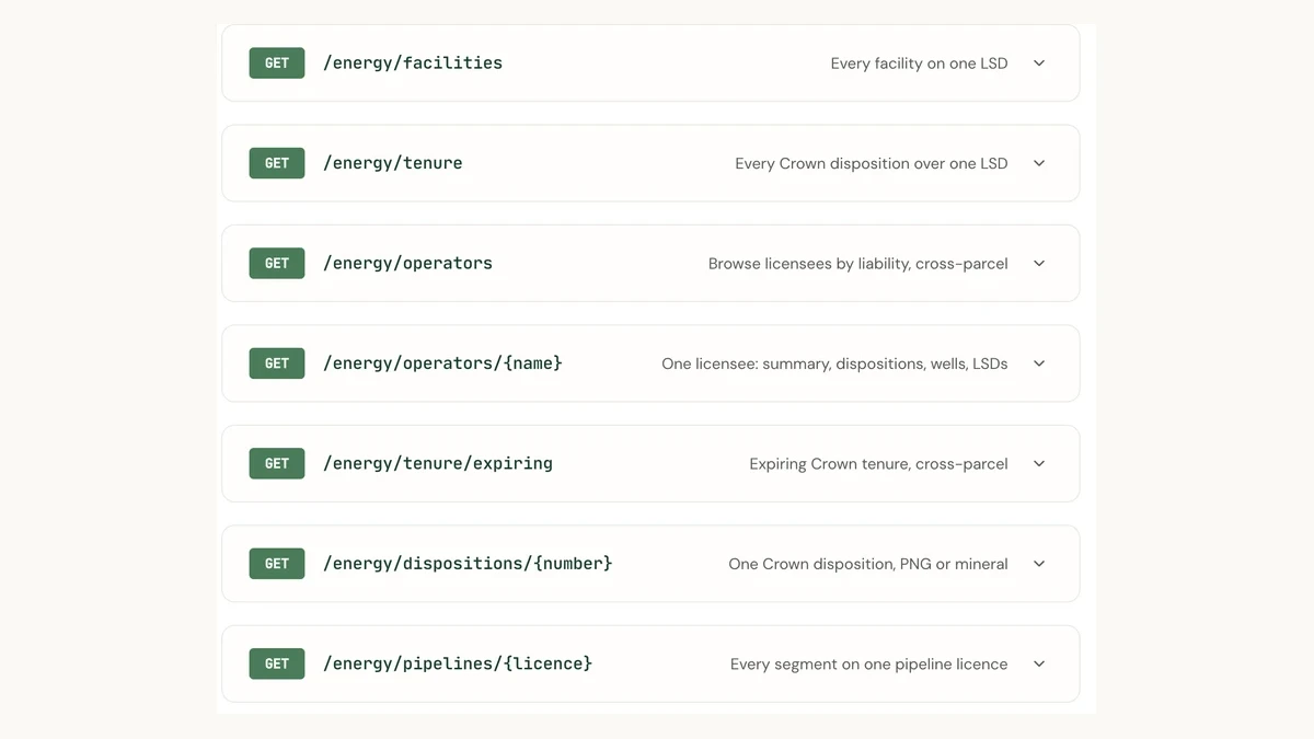
The Energy API docs now cover ten endpoints in total:
Single-parcel report
/energy/report: the full LSD energy report (summary, production, wells, pipelines, facilities, tenure, alternative energy, geometry)
Paginated collection endpoints
/energy/wells: well list per LSD, filterable by status (active, abandoned, suspended, orphan) and operator/energy/pipelines: pipeline segments per LSD, filterable by substance, status, and operator, default-sorted by H2S content/energy/facilities: facility list per LSD, filterable by category, status, and operator/energy/tenure: Crown PNG and mineral tenure per LSD, filterable by tenure kind, with an expiry window parameter
Cross-parcel endpoints
/energy/operators: operator directory, searchable by licensee name or BA code, sortable by orphan count, active wells, or total dispositions/energy/operators/{name}: operator detail with summary, dispositions, wells, and LSD views/energy/tenure/expiring: expiring Crown dispositions across all LSDs, filterable by operator, type, and tenure kind/energy/dispositions/{number}: single disposition detail by PNG number or mineral slug/energy/pipelines/{licence}: single pipeline licence detail by AER licence number
Each endpoint includes parameter definitions, response shapes, and code examples. The full specification is also in the OpenAPI YAML, which means developers using code-generation tools can generate typed clients against the complete Energy API surface.
For developers already using the Energy API report endpoint, nothing changes. The collection endpoints have been live and stable; the documentation now matches what is available.
For background on what the Energy API returns and how to get started, see Ag API and Energy API: Build Applications on Township Canada's Agricultural and Energy Parcel Data.
Agriculture drought fix: quarter-section inputs now return drought data
The agriculture parcel report includes a drought card that shows the current Canadian Drought Monitor class (D0 through D4) for the queried parcel. The data comes from a spatial join between the parcel's geometry and the national drought polygons.
The report works with two input paths. Most users search by legal land description (an LSD like 06-32-048-07W5), which resolves to a geometry through the LSD lookup table. Some users enter a quarter section directly (like NW-32-048-07W5), which matches against the quarter-section summary table without going through the LSD resolution step.
The drought lookup was only running for the LSD path. When a user entered a quarter section directly, the report returned soil data, crop rotation, productivity scores, and land use, but the drought card came back empty. The spatial join against the drought polygons used the LSD lookup table, and a direct quarter-section input never matched that table, so the join returned no rows and the code moved on without trying the quarter-section geometry.
The fix adds a fallback: when the LSD-based drought join returns no rows and the input is a direct quarter section, the lookup runs again against the quarter-section geometry table. The drought card now returns data for both input paths.
If you subscribe to the Agriculture Bundle and previously saw an empty drought card when entering a quarter section directly, that is resolved. The drought data was always available for the parcel; it was the lookup path that was incomplete.
API onboarding: all 8 products visible
A developer signing up for a Township Canada API key previously saw four products in the onboarding wizard: Search, Autocomplete, Batch, and Maps. Those are the original four APIs, and they remain the entry point for most integrations: convert legal land descriptions, get type-ahead suggestions, run bulk conversions, and serve survey grid tiles.
Four more products were available but invisible during onboarding: Ag, Energy, Ag Tiles, and Energy Tiles. A developer who wanted the Ag API or the Energy API had to discover them through documentation or the developer portal after completing setup. The onboarding wizard, designed before those products launched, only knew about the original four.
The wizard now shows all eight products with their pricing tiers. A developer evaluating the Energy API for a lease management tool, or the Ag Tiles API for a farmland mapping application, sees the product, its price, and its tier options during initial setup. Each product links to its documentation section, and the checkout flow handles the selected product and tier directly.
The eight API products, each subscribed independently:
| Product | What it does | Starting price |
|---|---|---|
| Search | Legal land description geocoding | $20 CAD/mo |
| Autocomplete | Type-ahead suggestions for legal locations | $20 CAD/mo |
| Batch | Bulk CSV conversion | $40 CAD/mo |
| Maps | Survey grid PMTiles vector tiles | $20 CAD/mo |
| Ag | Agriculture parcel report per quarter section | $50 CAD/mo |
| Energy | Energy parcel report per LSD | $50 CAD/mo |
| Ag Tiles | Agriculture data layer tiles | $50 CAD/mo |
| Energy Tiles | Energy data layer tiles | $50 CAD/mo |
Search, Autocomplete, and Maps start at $20 CAD per month on the Build tier. Batch starts at $40 CAD per month. The domain-specific products (Ag, Energy, Ag Tiles, Energy Tiles) start at $50 CAD per month. All eight share the same API key management. Report and location APIs use the X-API-Key header; tile APIs use the api_key query parameter.
What to do next
If you build on the Energy API, open the API documentation and check the collection endpoints. The operator directory, expiring tenure list, and paginated well and pipeline queries are documented with parameters, response schemas, and code examples.
If you use the Agriculture Bundle and enter quarter sections directly into the search bar, the drought card on the parcel report now returns data. No action needed on your side.
If you are evaluating Township Canada's APIs for a new project, the onboarding wizard shows all eight products from the start. For background on the data behind the Ag and Energy APIs, see What's Behind the Map: Township Canada's Energy and Agriculture Data Sources.