By Township Canada
Question-First Parcel Overview: How Township Canada Now Answers Land Questions, Not Just Shows Data
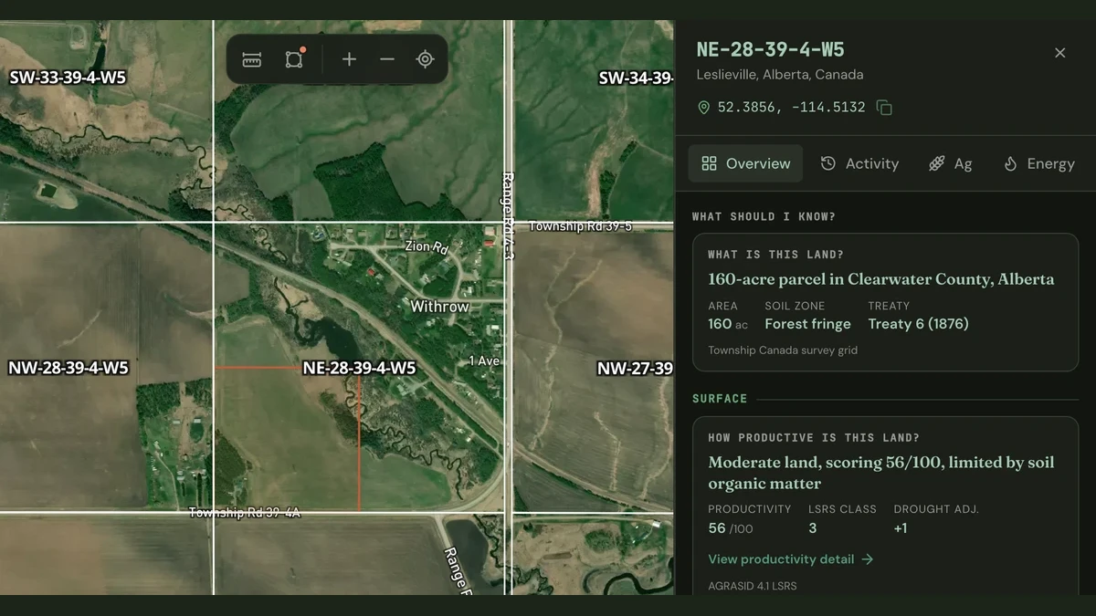
The parcel report sidebar now opens with ranked question cards. Each card answers a real investigation question and links directly to the evidence.
Open a quarter section on Township Canada today and you will notice something different. The parcel report sidebar no longer starts with a row of data tabs. It starts with questions such as: What is this land? How productive is it? What is underground? Who holds tenure?
Each question is a card. Each card shows an answer drawn from the data already on the parcel, and each answer links to the evidence: a report tab, a drill-down frame, or a map layer. If you hold the Agriculture Bundle, you see surface cards with soil and crop data. If you hold the Energy Bundle, you see subsurface cards with wells, pipelines, and Crown tenure. If you hold both, you see cross-bundle cards that connect what is growing with what is underneath it.
This is the question-first Overview. It replaces the old tab-and-scan approach with an investigation surface that tells you what matters about a parcel before you decide where to look.
The problem it solves
A parcel report used to work like a filing cabinet. Open the sidebar, pick a tab, scan the data, decide whether it matters, switch to the next tab, repeat. A land technician running due diligence on a Peace River quarter section with both agriculture and energy activity would open the Energy tab to check well count and tenure status, switch to Agriculture to check soil productivity, then mentally connect the two. The data was there, but the connection was the reader's job.
That workflow assumes you already know what to look for. A first look at an unfamiliar parcel offers no signal about which tab matters most, whether there is anything urgent, or whether the surface and subsurface data interact.
How the Overview works
The Overview organises the parcel into investigation questions, each resolved against the actual data on the quarter section.
What is this land? The identity card shows the legal land description, the survey system, the quarter section's acreage, and whether it sits within a treaty boundary. This card appears for every parcel, regardless of bundle.
How productive is it? For Agriculture Bundle subscribers, this card reports the LSRS productivity score (where available in Alberta), the CLI capability class, the dominant soil order, and the five-year crop rotation. If the parcel is in Saskatchewan or British Columbia, the card draws from the provincial soil survey instead.
What is underground? For Energy Bundle subscribers, this card counts the wells on the parcel, broken down by lifecycle status (active, suspended, abandoned, orphan), and reports the pipeline segments crossing it. If any wells are orphaned or abandoned, the card flags them.
Who holds tenure? Also for Energy Bundle subscribers, this card lists the Crown petroleum-and-natural-gas and mineral dispositions that overlap the parcel, with the days remaining until each one expires. When an expiry is approaching, the card surfaces it.
Ranked by relevance, not fixed position
The cards are not in a fixed order. An answer about 12 active wells and an expiring Crown disposition ranks higher than a card that reports zero pipelines. Cards with no data for the province (Manitoba production figures, for example) say "not published for Manitoba" instead of showing a zero. That distinction matters: "none found" and "not published" are different findings, and the Overview never conflates them.
Cross-bundle intelligence
When you hold both the Agriculture and Energy bundles, additional cards connect the two domains on the same parcel. A quarter section can carry a high productivity score and an active well pad at the same time. The cross-bundle cards state that co-location as a fact, without inferring legal or financial consequences. The surface-rights conversation, the farmland appraisal, or the acquisition analysis benefits from seeing both in one place.
Investigation brief
At the top of the Overview, a generated brief summarises the parcel's current posture in one or two sentences: whether the footprint is live or dormant, measured from real activity dates (well licence dates, last production month, tenure issue dates). The brief only makes claims that the data supports. Where published event dates are sparse, it says so instead of guessing.
Evidence actions and follow-up chips
Every answer card includes an evidence action. Tapping it opens the relevant tab, pushes a drill-down frame (to the operator's full well footprint, for example), or lights up the corresponding map layer. Below the cards, follow-up chips suggest the next question: "Show wells on map," "View expiring tenure," or "Save to project." The chips are context-aware and only appear when the action is available for the current parcel and entitlement.
A real investigation
Consider a land technician evaluating NW-22-83-24-W5, a quarter section in the Peace River region of northwestern Alberta. Both agriculture and energy activity overlap here.
With the old sidebar, the technician would open the Energy tab to see the well count, check each well's status, switch to the tenure tab to review Crown dispositions, then open the Agriculture tab to check whether the land has any productivity rating.
With the question-first Overview, the sidebar opens and the ranked cards present the findings immediately. The identity card confirms the legal land description and acreage. The subsurface card reports the well count and flags any orphan or abandoned wells. The tenure card shows the active Crown PNG dispositions and their expiry dates. The productivity card reports the LSRS score and the dominant soil order. A cross-bundle card notes that both energy infrastructure and agricultural soil data exist on the same parcel.
Each card links to its evidence. The technician can drill into a specific well's operator footprint, light up the pipeline layer on the map, or jump to the soil detail, all without scanning through tabs to figure out what matters first.
Data-state honesty
The Overview is explicit about what it does not know. Three rules govern how absent data renders:
- None found means the province is covered and the data source returned zero results. Zero wells on a covered Alberta LSD is a real finding.
- Not published means the data source does not carry that information for the province. Well production volumes are not published through Petrinex for Manitoba, so the card says "not published" rather than showing a zero. Saskatchewan Crown PNG tenure does not publish expiry dates, so the tenure card states that instead of implying no expiries exist.
- Locked means the data exists but requires a bundle the user does not hold. Locked cards still show a truthful finding from the freemium fields (well count and orphan flags travel outside the bundle), so even a Starter user sees real information, not a blank paywall.
These distinctions are enforced by a province capability model that records the measured coverage fraction for each dataset in each province. A 4% coverage rate for Alberta CLI capability data is not treated the same as 100% coverage for BC pipeline segments. The Overview renders only claims the data can support.
What else shipped with this release
Save to project now appears in the report sidebar footer. Previously, saving a parcel to a project was only available from search result cards. Now you can save any parcel you are investigating directly from the report.
Manitoba energy bundle fix: the /api/report/[lld] endpoint now correctly includes Manitoba wells. The previous version missed the Manitoba wells query path entirely, so Manitoba parcels returned no well data even for Energy Bundle subscribers. That is fixed.
39 unit tests cover the shared answer model (shared/parcelAnswers/). Every question resolver, every data-state transition, and every cross-bundle interaction is tested. The model is pure JavaScript with no Vue dependencies, shared between client and server.
How to access it
The question-first Overview is on by default for all Pro and Business subscribers who hold an Agriculture Bundle or Energy Bundle, or both. Open any parcel on the map and the report sidebar opens with the Overview.
Subscribers without a bundle still see the identity card and freemium findings. To see the full investigation surface, add a bundle from your account or the pricing page.