By Township Canada
AER CCS Tenure Proposals Closed June 30: What Happens to Your Location Data Next
The AER CCS pore space tenure deadline has passed. Here's how the 60 to 90 day review works, what it means for your quarter sections, and how to track adjacency while you wait.
You submitted your pore space tenure application on June 30. The DLS descriptions are filed, the GeoJSON exports are in the package, and the AER has your proposal. Now what?
The short answer: your application enters a 60 to 90 day review queue. But surface project planning doesn't stop because the subsurface tenure is under review. Quarter sections that overlap your submission zone are in regulatory limbo, adjacent operators need to know about potential conflicts, and your own team needs to track what's happening around the proposed storage formation while the AER makes its decision.
This post covers what the review period actually looks like, which quarter sections are affected, and how to keep your location data current while you wait for a disposition.
How the AER Reviews a CCS Pore Space Tenure Application
The AER's CCS tenure evaluation process follows a structured review path. After the June 30 intake deadline, submitted applications are assessed in the order they were received.
The review checks three categories of information:
Geological assessment. The AER verifies that the proposed storage formation (the deep saline aquifer or depleted reservoir described in the application) can contain injected CO₂ at the volumes projected. The geological model submitted with the application is cross-referenced against the AER's own formation data for the described DLS sections.
Legal land description verification. Every DLS section, quarter section, and LSD in the application is checked against the AER's spatial database. Section-level pore space tenure descriptions must match the geological formation boundary. Surface tenure descriptions (injection wells, monitoring wells, pipeline corridors) must resolve to valid parcels. A meridian error or transposed section number flagged at this stage triggers a deficiency notice back to the applicant.
Conflict screening. The AER checks whether any proposed pore space tenure sections overlap with existing licensed tenure, whether adjacent formation rights are held by another operator, and whether any surface rights conflicts exist with the proposed infrastructure locations. For a storage formation in the Heartland corridor, where multiple CCS projects target the same deep saline aquifer, this step can take the longest.
The typical timeline from intake to disposition decision is 60 to 90 days. Applications with deficiencies (location errors, incomplete geological data, or unresolved conflicts) take longer because each deficiency notice restarts part of the review clock.
What "Under Review" Means for Your Quarter Sections
While a pore space tenure application is under review, the proposed DLS sections and quarter sections exist in a specific regulatory state: they are not yet licensed, but they are flagged in the AER's system as subject to a pending application.
For your project team, this creates three practical concerns:
Surface planning must continue. Injection well site preparation, pipeline route planning, and facility siting don't wait for subsurface tenure confirmation. Your land team is still filing surface lease agreements, negotiating rights-of-way, and scheduling survey crews for the proposed injection well locations. Each of these activities references the same DLS descriptions that are sitting in the AER review queue.
Adjacent operators may file competing or overlapping applications. If a neighbouring operator's formation model extends into sections that your application also covers, the AER's conflict screening process flags both applications. Neither applicant receives automatic notification of the overlap. You discover it when the AER issues a deficiency notice or when the disposition decision addresses the conflict.
Subsurface tenure changes affect surface rights negotiations. A surface rights holder whose quarter section sits above a proposed storage formation may factor the tenure application into lease negotiations, even before disposition. Land technicians working these agreements need to know which quarter sections are inside the proposed tenure zone and which are adjacent.
Tracking Adjacency During the Review Period
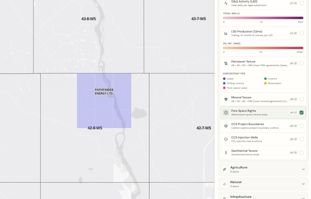
The CCS Tenure Layer on Township Canada's interactive map shows AER-licensed pore space tenure zone boundaries overlaid on the DLS survey grid. During the review period, the layer shows the current state of granted tenure, not pending applications, because the AER publishes tenure data only after disposition.
That distinction is important. The layer tells you what has already been granted in the formation you're targeting. If a neighbouring project received a disposition while your application was in queue, that new tenure boundary appears on the map as soon as the AER publishes it.
Here is how CCS project operators use this during the review window:
Monitor for new granted tenure adjacent to your application area. A new pore space tenure grant near your proposed sections could indicate a potential formation conflict that the AER's review hasn't surfaced yet. Toggle the CCS Tenure layer from the Energy category in the map layers panel and check the sections adjacent to your proposed zone.
Verify your own surface tenure descriptions against the current map. While the subsurface decision is pending, surface work progresses. Each new surface lease, injection well licence, or pipeline right-of-way filing references DLS descriptions from your original application. Confirming those descriptions against the interactive map catches any transcription errors before they reach the AER as a separate filing.
Export updated location data for ongoing regulatory filings. CCS projects generate regulatory paperwork throughout the review period: environmental impact assessments, surface rights board applications, and municipal development permits. Each filing references DLS descriptions from the project area. The batch converter and Batch API produce GPS coordinates and GeoJSON from the same DLS list used in the original tenure application, in the formats these downstream filings require.
The GeoJSON Export Workflow for Post-Deadline Filings
The tenure application package is filed, but the location data it contains continues to serve other regulatory and project management needs. A CCS project in the review period typically generates three to five additional filings that reference the same set of DLS descriptions.
Rather than re-entering each location manually for every filing, the Business plan batch converter processes the full list in a single upload:
- Upload the same CSV of sections, quarter sections, and LSDs from the original AER application
- Export as GeoJSON for environmental impact assessment maps
- Export as KML for municipal permit submissions
- Export as CSV with GPS coordinates for internal project tracking databases
For teams that have integrated Township Canada's Search API or Batch API into their own GIS or project management tools, the same legal land descriptions return updated coordinates and boundary data with every call. When the AER publishes a disposition decision and the CCS Tenure Layer updates, the API data reflects the current licensed state.
For the technical details of how DLS legal land descriptions flow through each CCS tenure type, from pore space tenure through injection well licensing to surface rights, the carbon sequestration industry guide covers each stage.
What a Disposition Decision Looks Like
When the AER completes its review, the disposition decision is published as an order that specifies:
- The granted pore space tenure area, described by its DLS section boundaries
- Any conditions on the tenure (monitoring requirements, injection rate limits, formation pressure thresholds)
- The tenure term and renewal provisions
- Any sections excluded from the original application due to conflicts or geological concerns
A positive disposition means the DLS sections in the granted area are now licensed pore space tenure. They appear on the CCS Tenure Layer as granted tenure boundaries. Surface project planning can proceed with confidence that the subsurface rights are secured.
A partial disposition, where some sections are granted and others are excluded or deferred, requires updating the project's DLS location data. The batch converter handles this: upload the revised section list, export updated GeoJSON, and the project maps reflect the actual granted boundaries rather than the proposed ones.
If the AER issues a deficiency notice instead of a disposition, the application returns to the applicant for correction. The most common deficiency categories involve location data: a section number that doesn't match the geological model boundary, a meridian reference that places pore space tenure in the wrong part of the basin, or a surface location that conflicts with an existing licence.
For the verification workflow that catches these errors before submission, see AER CCS Pore Space Tenure: How to Identify Quarter Sections in Licensed Tenure Zones. The same checklist applies when responding to a deficiency notice.
Keeping Location Data Current Through the Review Cycle
The June 30 deadline marked the end of the intake window, not the end of the location data workflow. For CCS projects now in the AER review queue, legal land descriptions remain active working data: referenced in surface filings, shared with contractors and consultants, and updated when the disposition decision arrives.
The CCS Tenure Layer is free at all tiers, so any team member can check the current state of granted tenure in the project area. The batch converter and full export formats (GeoJSON, KML, Shapefile, CSV) are available on the Business plan, which also includes team access for multi-consultant project teams working across surface and subsurface tenure.
For the pre-deadline workflow on how CCS lease blocks are mapped and verified before filing, see Mapping CCS Lease Blocks Before the AER June 30 Deadline.