Parcel Investigation and Land Intelligence for Western Canada
Evaluate a western Canadian quarter section across wells, tenure, soil, and crop history in one parcel investigation using Township Canada's Energy and Agriculture data bundles.
Parcel Investigation and Land Intelligence for Western Canada
You are evaluating a quarter section in western Canada. A pre-acquisition review, a surface lease renewal, or a farmland purchase each demands answers about what sits on and under the land: active wells, pipeline crossings, Crown tenure status, soil productivity, and crop rotation history. Pulling that picture together from separate provincial databases, federal rasters, and regulatory portals can take hours per parcel.
Township Canada's parcel report brings this data together. When the Energy Bundle and the Agriculture Bundle are both active, the report sidebar shows energy infrastructure, Crown tenure, soil data, and crop history on the same quarter section.
The old way, and the way that works
Before: a land technician opens AER OneStop to check wells, pulls Crown tenure status from a separate provincial portal, downloads AAFC crop inventory rasters into GIS to review rotation history, and cross-references soil survey data from yet another source. Each system uses its own identifier, and reconciling them against a single legal land description means copying coordinates between tabs.
After: search the legal land description (for example, NW 36-042-03W5) in Township Canada. The parcel report sidebar shows wells, pipelines, facilities, Crown PNG tenure, soil survey attributes, crop rotation, and productivity scores for that quarter section. Energy and agriculture layers render together when both bundles are active.
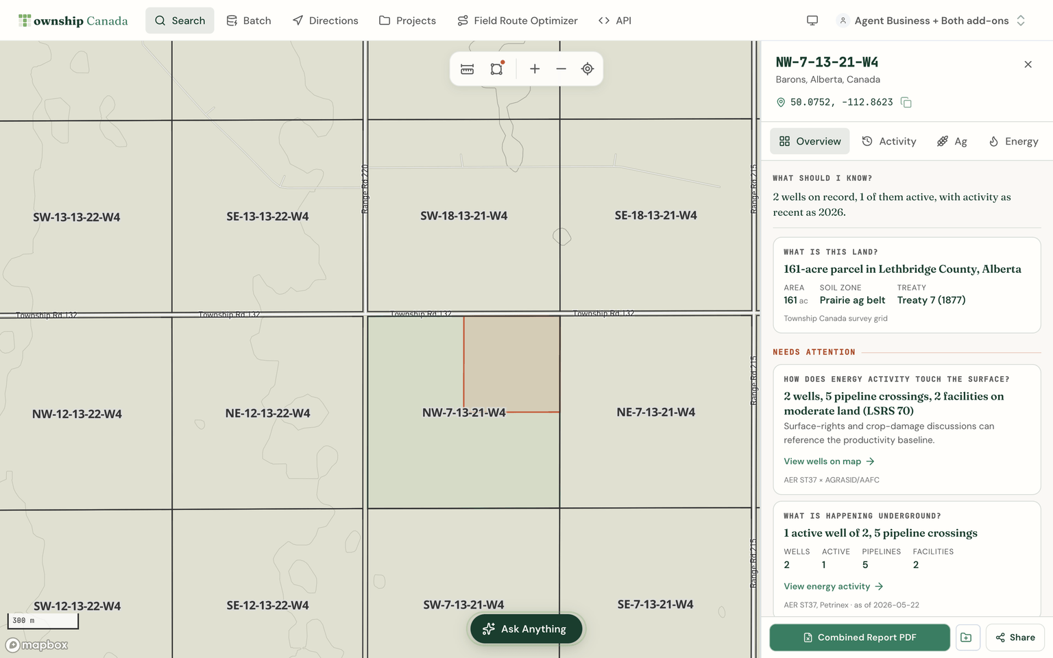
The example screenshot uses quarter section NW-7-13-21-W4, captured with both bundles active.
What the data shows
The Energy Bundle plots provincial well records with orphan and abandoned flags where published. Sources include Alberta AER ST37, Saskatchewan GeoHub, the BC Energy Regulator, and Manitoba provincial records. It carries provincial pipeline and facility data, including Alberta ST76 and ST102, Crown PNG and mineral tenure with expiry alerts, CCS pore space tenure (Alberta), geothermal tenure (Alberta), and Petrinex 12-month production data.
The Agriculture Bundle shows AAFC crop inventory with five-year crop rotation (national), a unified soil survey combining Alberta AGRASID, the Saskatchewan provincial survey, and the BC soil survey (with drainage, slope, and salinity filters), CLI land capability (national), the LSRS Productivity Score for Alberta parcels, and drought monitoring.
Both datasets render on the same DLS and NTS grid, so a quarter section in an active drilling area with agricultural potential shows all of that context in one parcel report.
The Overview starts with ranked answers to land questions and a short investigation brief. Its Investigation Hub groups findings under Surface, Subsurface, Interests, and Constraints, with cross-bundle findings under How things interact. Findings that need attention appear above the groups.
When both bundles are active, relationship cards connect agricultural productivity, energy infrastructure, and tenure on the same parcel. Each card links to a report tab, a drill-down, or map evidence. Cards describe the overlap supported by the data without inferring ownership, liability, or compensation.
Subscribers without a required bundle can still see freemium findings. Locked cards explain which additional evidence requires an add-on; missing provincial data is labelled separately from a confirmed zero.
Who uses this
Pre-acquisition due diligence. A landman evaluating a surface lease needs well density, abandonment history, and Crown tenure status on the parcel before recommending terms. The Energy Bundle's well and tenure layers answer those questions directly on the DLS grid. See Orphan Well Due Diligence for the detailed M&A and surface-rights workflow.
Farmland evaluation. An agronomist or investor assessing a prairie quarter section needs soil productivity and crop rotation history to estimate yield potential. The Agriculture Bundle provides LSRS scores in Alberta and five-year crop history nationally. See Farmland Due Diligence: Soil and Crop Data for the evaluation workflow.
Crown tenure monitoring. Companies holding Crown PNG or mineral leases need to track expiry dates. The Energy Bundle's tenure layers carry expiry alerts, and the parcel report shows which Crown interests are active on a given quarter section.
Surface lease review. Before renewing or negotiating a surface lease, both parties benefit from seeing the well count, pipeline crossings, and land capability on the parcel. See Surface Lease Legal Descriptions for how legal land descriptions tie into the filing process.
Energy Bundle and Agriculture Bundle
Both bundles are $100 CAD per month add-ons on a Pro ($20/month) or Business ($40/user/month) plan. Add one or both. The Energy Parcel Report PDF and Agriculture Parcel Report PDF are available for export when the corresponding bundle is active.
Related
- Legal Land Descriptions for Oil and Gas
- Legal Land Descriptions for Agriculture
- AER ST37 Wells Data Source
- Crown PNG Tenure Data Source
Look up a quarter section
Search any DLS, LSD, or NTS reference and see what the Energy and Agriculture layers show for that parcel. Pricing.
FAQ
Can I see energy and agriculture data on the same parcel? Yes. When both the Energy Bundle and the Agriculture Bundle are active, their map layers and report tabs render together on the same quarter section.
Which provinces does this cover? Wells cover Alberta, Saskatchewan, British Columbia, and Manitoba. Pipelines and facilities cover Alberta, Saskatchewan, and British Columbia. Crop inventory and CLI capability are national. Detailed soil polygons cover Alberta, Saskatchewan, British Columbia, and Manitoba. The LSRS Productivity Score is Alberta only.
Do I need both bundles? Each bundle is independent. A land technician focused on well proximity and tenure may only need the Energy Bundle. An agronomist evaluating soil and crop data may only need the Agriculture Bundle. Teams working across both domains benefit from adding both.
Related Articles
Crown PNG Tenure: Western Canada Petroleum and Natural Gas Agreements
Crown petroleum and natural gas tenure across Alberta, Saskatchewan, British Columbia, and Manitoba - leases, licences, and pore-space agreements - with holder, status, and days-to-expiry, on the map and parcel report.
Orphan Well Due Diligence: M&A and Surface Rights Workflows
How to use the orphan flag and per-operator rollup for operator-level closure exposure analysis and surface-rights diligence.
Legal Land Descriptions for Agriculture
How farmers, agrologists, and agricultural lenders use DLS and LSD legal land descriptions for crop insurance, land leases, and field mapping across the prairies.