By Township Canada
Saskatchewan, BC, and Manitoba Energy and Agriculture Map Layers Are Now Live
Township Canada's Energy and Agriculture Bundles now cover SK, BC, and MB: wells, pipelines, facilities, soils, BC ALR, and ag crown land on the DLS and NTS grids you already use.
A landman working a Saskatchewan oil play has been juggling four tools all morning: SaskGIS for wells, the SK Ministry of Energy and Resources pipeline viewer for the gathering lines, a paper land survey to keep track of the DLS quarter sections, and a separate browser tab for the operator's lease boundaries. None of them speak the same coordinate language. By the time the picture comes together, the morning is gone. A landman in northeast BC working the Peace River block has the same problem with a different cast of portals. A farmland buyer in Manitoba has it again: ag soil maps in one place, well data nowhere on the same screen.
Today that changes. Township Canada's Energy and Agriculture Bundles now cover Saskatchewan, BC, and Manitoba alongside Alberta. Wells, pipelines, facilities, soils, the BC Agricultural Land Reserve, ag crown land, oil-gas pools, and FWA wetlands are live as toggleable map layers on the same DLS and NTS grids your descriptions already reference.
What's new in each province
Saskatchewan. Seven layers added: wells, pipelines, facilities, oil-gas pools, soils, pastures, and ag crown land. All of them render on the DLS grid that SK landmen and SCIC filers already work in. The Saskatchewan well data covers the Williston Basin south of Estevan, the Bakken trend, the heavy oil belt around Lloydminster, and everything in between.
British Columbia. Eight layers added: wells, pipelines, facilities, oil-gas fields, the BC Agricultural Land Reserve (ALR) with labels, FWA wetlands, the BC soil survey, and the BC ag capability layer. BC professionals can finally see northeast BC well activity on the same map as the NTS grid and, in the Peace River block, the DLS grid that overlaps it. A new parcel-report endpoint also resolves BC legal land descriptions via NTS/DLS fallback, so the BC NTS converter returns the same parcel context for either reference style.
Manitoba. Two additions: energy well data and ag soil layers in parcel reports. Manitoba is not in Petrinex, so the well data is loaded through a separate path (Manitoba's own provincial registry). The ag soil layers, detailed soil polygons and component data, drive the parcel report soil section for any MB quarter section you look up through the Manitoba legal land description converter.
The AI Assistant's tenure tools (list_expiring_tenure, query_mineral_tenure) now accept ab, sk, bc, and mb as province inputs, so an analyst can ask "list mineral tenure expiring in SK in the next 90 days" and get an answer that previously only worked for Alberta. Petroleum and mineral tenure paint also includes MB as of this release.
A Saskatchewan example: wells and pipelines on a DLS quarter
Take a landman checking a quarter section in the Lloydminster heavy oil belt, say SW-22-49-23-W3, in the Maidstone area just east of Lloydminster. The workflow used to be: SaskGIS for the well permit map, a separate SK Energy and Resources viewer for the pipeline corridors, a third tab for the operator name, and back to the legal land description converter to translate everything into the LSD format that goes on the surface lease.
Now: enter SW-22-49-23-W3 in the Saskatchewan legal land converter, toggle on the SK Wells, SK Pipelines, and SK Facilities layers, and the picture is on one screen. Wells render as points on the DLS grid with status and operator on hover. Pipelines render as line work with their licence numbers. Facilities (batteries, custom treaters, the rest) sit as labelled markers. A single click on a well opens the parcel report with the surrounding wells, pipeline crossings, and any oil-gas pools that share the quarter.

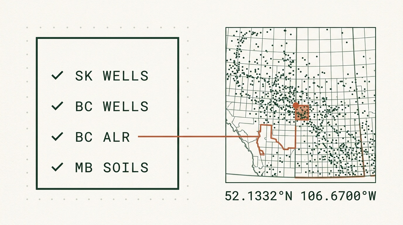
A northeast BC example: NTS reference, BC wells, ALR
For the BC side, the move is similar but the reference frame shifts. Northeast BC professionals work with NTS map sheets like 094A/03 (Peace River area, near Fort St. John) and, inside the Peace River block, the DLS grid. Until today, BC well data lived in a separate provincial tool and was a pain to reconcile against the NTS sheet you already had open.
Enter 094A/03 in the BC NTS converter, toggle on BC Wells, BC Pipelines, and BC Oil & Gas Fields, and the whole well inventory inside that map sheet shows up on the same view. Add the BC ALR layer if the same parcel touches farmland: a single toggle reveals whether the property sits inside the Agricultural Land Reserve, which is the difference between a routine rural transaction and one that needs an ALR exclusion application. The FWA wetlands layer surfaces water features that affect surface lease setbacks and reclamation plans.
Agriculture: SK crown land, BC ALR, MB soils
The Agriculture Bundle expansion is the other half of this release. SK adds ag crown land and soils layers, the working dataset for farmland buyers and crop insurance adjusters checking provincial leases and rotation history. A buyer evaluating a parcel near Watrous, for example, can pull up SE-5-22-20-W2, see the soil polygons, check whether the adjacent half-section is provincial pasture, and confirm the productivity baseline before the purchase agreement is signed.
BC's ALR layer is the standout for rural real estate. Any agent listing a rural BC property near Williams Lake or in the Okanagan can confirm the ALR designation in seconds: no LTSA lookup, no separate ALR commission viewer. Combined with the ParcelMap BC layer that shipped earlier (see the ParcelMap BC integration post), BC agents now have the survey grid, parcel boundaries, ALR status, and soil capability on a single screen.
Manitoba's contribution is the soil layers feeding parcel reports. A buyer looking at a MB quarter section, say NE-20-3-5-W1 in the Pembina Valley near Morden, gets the soil subgroup, drainage, and capability rating on the same report card that summarizes any energy activity on the parcel.
How to turn the layers on
The new layers are part of the existing Energy and Agriculture Bundles: no new SKU, no separate upgrade. If you already subscribe to either bundle on Pro or Business, the SK, BC, and MB layers appeared in your map layers panel today. If you don't, the bundles stack on your plan; see the pricing page for the breakdown.
Open the Township Canada app, click the layers panel, scroll to the provincial sections, and toggle the layer you want. The layers compose: turn on SK Wells, SK Pipelines, and BC Wells together and the map renders all three across the SK/BC border without complaint.
If your work spans more than one province, and most O&G land work in western Canada does, see the oil and gas industry page for the cross-province workflow, or the agriculture industry page for the soil-and-tenure cross-references.