Saskatchewan Oil and Gas Wells and Pipelines on the DLS Map
View Saskatchewan's 65,000+ licensed wells, pipeline routes, facilities, and oil-gas pools on the DLS survey grid. Look up any SK well by LSD or quarter section.
Saskatchewan Oil and Gas Wells and Pipelines on the DLS Map
You are filing a well licence with the Saskatchewan Ministry of Energy and Resources, and the location field asks for a DLS legal land description: LSD 14-10-004-30-W2M. You know the quarter section, but you need to confirm the well sits where you think it does, check what other wells and pipelines are already on or near the parcel, and verify the oil-gas pool boundary before you submit. That means opening the ministry's well database in one tab, a DLS reference tool in another, and a separate map viewer to see the actual ground.
Saskatchewan has 65,000+ licensed oil and gas wells, the second-largest producing province in Canada after Alberta. Every one of those wells is located by a Dominion Land Survey legal land description, referenced to the W1M, W2M, or W3M meridians. Township Canada's Energy Bundle puts all of them on one interactive map alongside the DLS survey grid, pipeline routes, licensed facilities, and designated oil-gas pool boundaries.
How Saskatchewan's DLS Grid Differs from Alberta's
Saskatchewan and Alberta share the same Dominion Land Survey structure (townships, ranges, sections, quarter sections, and LSDs) but they reference different meridians.
Alberta spans the 4th, 5th, and 6th Meridians (W4M, W5M, W6M). Saskatchewan spans the 1st, 2nd, and 3rd Meridians (W1M, W2M, W3M). The 2nd Meridian runs near the Manitoba border at approximately 102°W, and the 3rd Meridian passes through central Saskatchewan near Saskatoon at approximately 106°W. Most of Saskatchewan's oil and gas activity (the Williston Basin heavy oil play around Lloydminster, the Bakken tight oil in the southeast, and the medium-gravity fields around Kindersley) falls in ranges referenced to W2M and W3M.
One practical advantage of the SK grid: Saskatchewan has no W4M correction-line discontinuities. Alberta's grid at W4M occasionally creates offset sections where the correction line adjusts for the curvature of the Earth. In Saskatchewan, the grid runs consistently across the province's flatter terrain with fewer survey anomalies to account for.
For the full structure of the DLS system, see the DLS system overview. For Saskatchewan-specific quarter section conventions and example coordinates, see the Saskatchewan province guide.
Looking Up a SK Well by LSD or Quarter Section
Enter any Saskatchewan DLS description into Township Canada's search bar (14-10-004-30-W2M, SE 10-004-30-W2M, or a full verbose description like Section 10, Township 4, Range 30, West of the 2nd Meridian) and the map zooms to the parcel with the DLS grid overlay showing township, section, quarter section, and LSD boundaries.
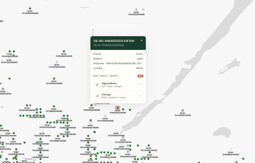
With the Energy Bundle, toggle the Wells layer in the map layers panel. SK wells appear as colour-coded circles on the DLS grid: green for active, amber for suspended, grey for abandoned. Each well carries its licence number, status, operator, and substance in the popup.
A landman checking a DLS quarter near Weyburn (say, LSD 14-10-004-30-W2M) can see every licensed well on and adjacent to the parcel, the pipeline segments crossing the section, and the named oil-gas pool boundaries that define the reservoir extent. That is three separate lookups in provincial databases, or one search on Township Canada.
SK Energy Map Layers
The Energy Bundle includes four Saskatchewan-specific data layers, all rendered on the DLS grid from pre-built PMTiles archives:
Wells
Saskatchewan's 65,000+ licensed wells displayed as interactive points, colour-coded by well status (active, suspended, abandoned, inactive). Zoom in and well licence numbers appear as labels. Each well popup shows the operator, substance, and current lifecycle status.
Pipelines
Pipeline and flowline segments across Saskatchewan, colour-coded by substance: crude oil and heavy oil in green, natural gas in red, sour gas in pink, water in blue. Transmission pipelines render thicker than gathering flowlines. Labels show the pipeline owner at higher zoom levels.
Facilities
Licensed facilities (batteries, compressor stations, gas plants, injection stations) rendered on the map with status-coded colours. Facilities carry the owner name, licence status, and facility type in the popup.
Oil and Gas Pools
Designated oil-gas pool boundary polygons from Saskatchewan's regulatory data. Pool boundaries render as outlines so the satellite imagery underneath stays visible, and pool names appear as labels when you zoom in. Useful for identifying which named reservoir a group of wells produces from, context that matters for acquisition targeting, reserves reporting, and regulatory filings.
These layers are also included in Township Canada's unified cross-province layers (Wells, Pipelines, Facilities, Fields & Pools), which combine AB, SK, BC, and MB data into single layers with province filter chips. A project that crosses the Alberta-Saskatchewan border can view wells continuously across both sides of the line without switching layers.
A Real-World Example: Weyburn-Area Due Diligence
A land technician is preparing a surface lease review for a quarter section in the Weyburn area, LSD 14-10-004-30-W2M, in the heart of the Williston Basin. The workflow:
- Search the LSD on Township Canada. The map centres on the parcel with the DLS grid overlay.
- Toggle the Wells layer. Active wells on the quarter section appear as green circles. Adjacent wells on neighbouring LSDs are visible at the same time.
- Toggle Pipelines. Pipeline segments crossing the section show up colour-coded by substance, with the owner name visible at zoom.
- Check the Oil and Gas Pools layer. The named pool boundary confirms the reservoir extent and which wells produce from the same pool.
- Open the parcel report. The Energy tab lists wells individually with operator, status, and substance, the detail needed for the lease file.
Without Township Canada, the same review requires cross-referencing the ministry's well database, a separate pipeline registry lookup, and a DLS converter to verify coordinates. With the Energy Bundle, it is one search and four layer toggles.
SK Agricultural Layers for Surface Lease Negotiations
Surface lease negotiations on energy-active land require context from both sides: what is underground and what is growing on top. Township Canada's Agriculture Bundle adds Saskatchewan-specific soil and crop layers alongside the energy data:
- Soils: The unified Soil Survey layer includes Saskatchewan provincial soil survey data with drainage and slope filter chips, relevant for assessing whether surface disturbance affects high-quality agricultural land.
- AG Crown Land: Saskatchewan's agricultural Crown land layer shows which parcels are Crown-held versus titled, a distinction that changes the surface access process entirely.
A landman working a surface lease near Kindersley can see the well and pipeline infrastructure on the Energy layers and the soil quality and Crown land status on the Agriculture layers, all on the same DLS quarter section. Both bundles are available on the Business tier.
Getting Started with SK Energy Layers
The Saskatchewan wells, pipelines, facilities, and oil-gas pool layers are part of the Energy Bundle, available on top of a Pro or Business plan. Toggle them in the map layers panel under the Energy category.
To convert a list of Saskatchewan well locations in bulk (for a regulatory filing, an asset inventory, or a lease audit), the batch converter handles CSV uploads of DLS descriptions at any scale. Download results as CSV, Shapefile, KML, GeoJSON, or DXF.
For a Saskatchewan-configured search experience with province-specific examples, visit the Saskatchewan legal land converter. For full plan details, see pricing.
Related use cases
Township Canada for Agriculture - Crop Insurance, Field Mapping, and Lease Verification
Process crop insurance claims by quarter section, verify lease boundaries, map field locations, and batch-convert hundreds of legal land descriptions for agricultural operations.
Township Canada for Farmers - SCIC/AFSC Filing, Field Mapping, and Lease Verification
Verify quarter section descriptions before SCIC and AFSC filings, map leased land, and convert legal land descriptions for the day-to-day work of running a Western Canadian farm.
Township Canada for Farmland Investors - Portfolio Mapping, Title Verification, and Land Research
Map farmland portfolios across multiple townships, verify legal descriptions against title records, and batch-convert acquisition pipelines for non-operator landowners and farmland funds.