Harvest Crop Insurance Claims: Batch-Convert Legal Land Descriptions to GPS for Field Inspections
How AFSC and SCIC crop insurance adjusters convert hail, drought, and frost claim locations to GPS coordinates during harvest season.
Harvest Crop Insurance Claims: Batch-Convert Legal Land Descriptions to GPS for Field Inspections
A July hailstorm cuts a 40 km path across central Alberta and your inbox fills with 90 claims in three days. Each claim references a quarter section or LSD: SW 22-038-27W4, NE 07-040-26W4, 14-33-039-27W4. Before you can inspect a single field, you need GPS coordinates for every location, a route that doesn't waste half your day doubling back on grid roads, and a way to verify that each claimed parcel actually falls inside the storm path.
That's the harvest-season workflow for AFSC and SCIC adjusters from July through October: hail, drought, excess moisture, and early frost claims arriving in volume, each one tied to a legal land description that needs to become a field visit.
The pre-planting gap
The existing crop insurance legal land description guide covers the spring workflow: verifying declared acres before the March 31 (SCIC) and April 30 (AFSC) deadlines. That process is about accuracy on paper, catching a wrong meridian or transposed township before the season starts.
Harvest claims are a different problem. You already know the descriptions are correct on the policy. Now you need to turn dozens or hundreds of those descriptions into a field inspection plan, fast, while the physical evidence of damage is still visible.
Step 1: Build your claims CSV
Start with the claim spreadsheet your office generates. The key column is the legal land description for each claimed parcel. A typical AFSC hail claim file might look like this:
claim_id,legal_land_description,crop,damage_type
HC-2026-4401,SW 22-038-27W4,canola,hail
HC-2026-4402,NE 07-040-26W4,wheat,hail
HC-2026-4403,14-33-039-27W4,barley,hail
HC-2026-4404,NW 15-038-28W4,canola,hail
The batch converter accepts CSV files with a column named legal_land_description, lld, legal, location, or description. Extra columns (claim ID, crop type, damage type) are preserved in the output, so you keep your claim metadata alongside the coordinates.
Step 2: Batch-convert to GPS coordinates
Upload the CSV to the batch converter. Township Canada processes each row, calculates the GPS centre point of the quarter section or LSD from official survey coordinate data, and returns latitude and longitude for every record. A file with 200 claims converts in seconds.
The output flags any descriptions that don't match a known parcel, so you can catch data entry errors (a mistyped range number, for example) before driving to the wrong location.
For a detailed walkthrough of the upload process, see the batch conversion guide.
Step 3: Plot claims on the map and plan your route
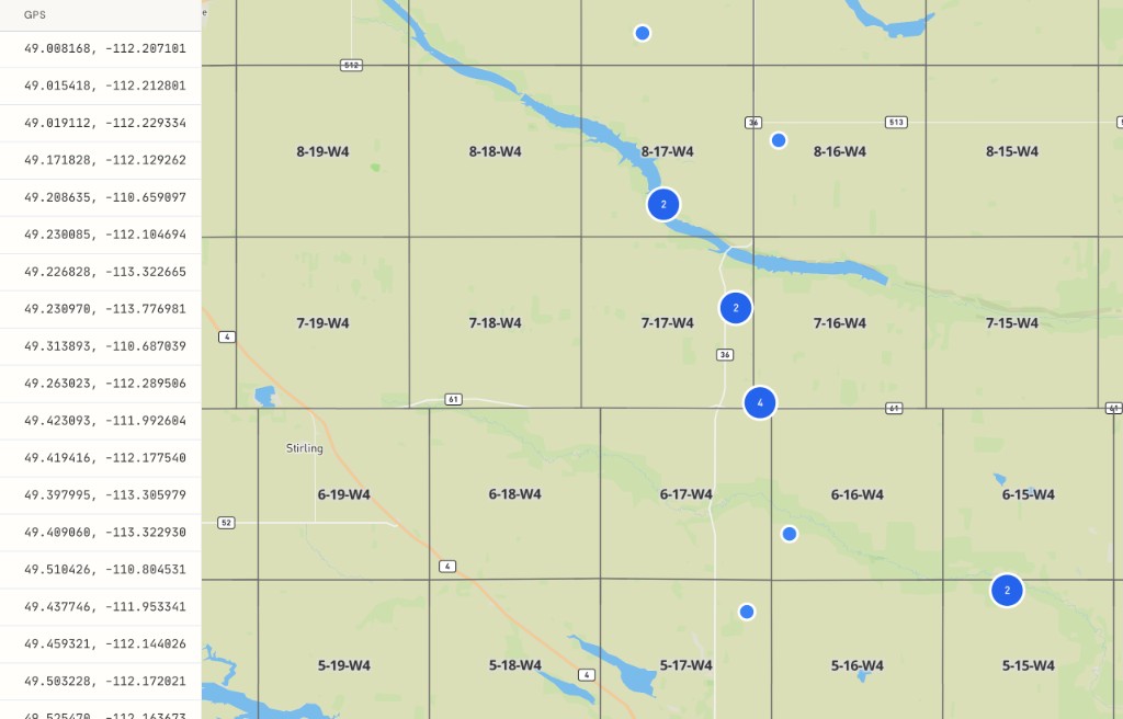
After conversion, display the results on the map. Every claimed parcel appears as a pin on the DLS survey grid over satellite imagery. This view immediately answers two questions:
- Storm path verification. Do the claimed parcels form a geographic cluster consistent with a hailstorm's track? An outlier 80 km from the rest of the swath may need a second look before committing to a field visit.
- Route planning. Group nearby claims into daily inspection runs. The route planner optimizes multi-stop routes across claimed parcels, so you visit every site in the most efficient order instead of zigzagging across township roads.
Step 4: Verify quarter section boundaries in the field
At each site, confirm you're standing on the correct parcel. The DLS grid overlay on Township Canada shows quarter section boundaries on satellite imagery, so you can match fence lines and field edges to the survey grid before documenting damage. If a producer's field straddles two quarter sections, you can verify which portion falls under the insured description.
Saskatchewan adjusters: SCIC and satellite forage claims
SCIC adjusters handling drought or forage claims under the satellite-based program should note that payouts are calculated at the township level. The section township range lookup confirms which township a quarter section belongs to, which matters when adjacent pastures fall in different townships with different satellite-derived triggers.
Plan, convert, inspect
The harvest claims workflow comes down to three steps: build your CSV, batch-convert to GPS, and plan your field route. The batch converter handles the conversion (Business plan required), and the route planner turns the results into an efficient inspection schedule.
For spring filing workflows, see the pre-planting crop insurance guide.
Related Articles
AAFC Crop History: Look Up 5 Years of What's Been Grown on Any Quarter Section
AAFC's Annual Crop Inventory shows dominant crop per pixel since 2009. Township Canada aggregates it to a 5-year rolling per-quarter summary with rotation and diversity score.
AER Facilities Map: 8 Categories from 40+ Petrinex Sub-codes
Township Canada collapses AER ST102 facility sub-codes into 8 clean categories (battery, gas plant, compressor, disposal, etc.) so the catalog UI stays readable across the full Alberta dataset.
AER Pipelines Map: Visualize Alberta Oil and Gas Pipelines on the DLS Grid
Township Canada renders every AER-licensed pipeline as a line layer with mid-point labels. For operators, integrity teams, and right-of-way planning.