Agriculture Parcel Data API for Canadian Developers
One GET request returns LSRS soil productivity, crop rotation history, CLI land capability, soil classification, and drought status for a supported quarter section in Alberta, Saskatchewan, or Manitoba.
What you can build with the Ag API
You are building a farmland evaluation tool, a crop insurance workflow, or an agronomist app. For each quarter section, your application needs soil productivity, crop rotation history, and land capability. That data exists across AAFC, AGRASID, and the Canada Land Inventory, but collecting it parcel by parcel does not scale.
The Township Canada Ag API returns all of it in a single GET request. Pass a supported quarter section in Alberta, Saskatchewan, or Manitoba as a legal land description, and the response comes back as JSON with productivity, cropping, soil, land use, drought, wetlands, hydrology, parcel context, and provincial detail. Use include= to select the sections your application needs.
What the response includes
Productivity: LSRS score (0 to 100, derived from AGRASID 4.1, Alberta only), LSRS class (1 to 7), the capping factor, and the Canada Land Inventory (CLI) capability class. The 0 to 100 score is Township Canada's own translation, not an official AAFC rating.
Cropping: dominant crop, rotation pattern (such as "Wheat-Canola-Peas"), and Shannon diversity index. Built from the AAFC Annual Crop Inventory, with a five-year rotation window in the current report response.
Soil: soil order, great group, subgroup, drainage, and slope. Sourced from AGRASID in Alberta, provincial soil data in Saskatchewan and Manitoba.
Land use: dominant AAFC land-use class, IPCC classification, and a percentage breakdown across the parcel.
Drought: current Canadian Drought Monitor class (D0 through D4) and assessment date.
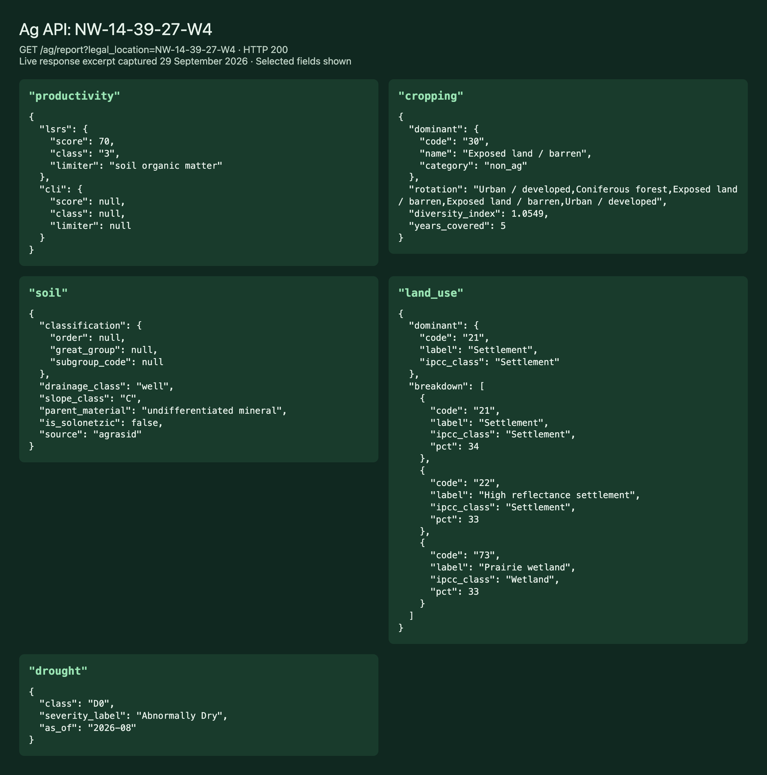
Response excerpt captured on September 29, 2026. Additional report sections are omitted from this view.
A concrete example
Here is a call for NW-14-39-27-W4, a quarter section near Red Deer, Alberta:
curl "https://developer.townshipcanada.com/ag/report?legal_location=NW-14-39-27-W4" \
  -H "X-API-Key: YOUR_API_KEY"
Your application can score that parcel by combining productivity, rotation diversity, soil drainage, and drought conditions from a single response.
Who builds on it
- Farmland evaluation tools: rank quarter sections by LSRS productivity, soil quality, and rotation diversity for buyers and investment funds.
- Crop insurance platforms: pull productivity and crop history for AFSC and SCIC workflows.
- Agronomist apps: surface soil, land capability, and drought conditions for seasonal planning.
- Agricultural lending tools: due diligence on quarter sections backing farm mortgages.
Coverage by province
| Data layer | Alberta | Saskatchewan | British Columbia | Manitoba |
|---|---|---|---|---|
| LSRS productivity score | Yes | No | No | No |
| CLI capability | Yes | Yes | Not supported | Yes |
| AAFC crop inventory | Yes | Yes | Not supported | Yes |
| Detailed soil polygons | AGRASID | Provincial survey | Not supported | Provincial survey |
| Drought monitor | Yes | Yes | Not supported | Yes |
The report API supports Alberta, Saskatchewan, and Manitoba. BC requests return 400 bc_not_supported; BC agriculture data remains available in the web app. Saskatchewan and Manitoba have no open LSRS productivity rating. Use available CLI capability data for cross-province comparisons.
Pricing
| Tier | Price | Requests/month | Rate limit |
|---|---|---|---|
| Build | $50 CAD/mo | 500 | 1 req/sec |
| Scale | $250 CAD/mo | 5,000 | 2 req/sec |
| Enterprise | $1,250 CAD/mo | 50,000 | 5 req/sec |
Build fits prototyping. Scale fits production applications pulling a few thousand reports per month. Enterprise fits high-volume integrations serving multiple downstream clients.
The Ag API is separate from the web app's Agriculture Bundle. If your application also needs to resolve legal land descriptions to GPS coordinates, combine it with the Search API or the Batch API.
Getting started
- Create an API key in your account settings.
- Subscribe to the Ag API at developer.townshipcanada.com/ag.
- Make your first call with
legal_locationset to any quarter section in western Canada.
Full response schema and code examples are on the API documentation page.
FAQ
Is the LSRS productivity score an official AAFC rating? The LSRS class (1 to 7) is official. The 0 to 100 score is Township Canada's own numeric translation, not an AAFC number. The API returns both.
Can I combine the Ag API with other Township Canada APIs? Yes. Use the Search API to resolve a legal land description to GPS coordinates, then call the Ag API for the parcel report. All APIs share the same X-API-Key header.
Other personas
Township Canada for Farmers
Verify SCIC and AFSC quarter sections before filing, map new leases before signing, and pull a full parcel report with LSRS productivity and 5-year crop history.
Township Canada for Farmland Investors
Map portfolios across multiple townships, verify titles against deal paperwork, and use Projects to organize acquisition pipelines.
Township Canada for Ag Retailers and Grain Companies
Map customer parcels across sales territories, route field agronomists efficiently, enrich CRM records via the API, and organize prospect lists in Projects.
Township Canada for Oil and Gas Operators
Wells with lifecycle status across Alberta, Saskatchewan, British Columbia, and Manitoba, plus pipelines, facilities, treaty overlay, and operator history snapshots, alongside batch conversion and API access.
Township Canada for CCS and Geothermal Developers
Pore space tenure boundaries, CCS project boundaries, injection wells, and geothermal tenure on the DLS grid - built for Alberta carbon capture and geothermal evaluation.
Township Canada for Surveyors and Geomatics Professionals
Native ArcGIS Pro locator, NTS grid for BC mineral claims, batch conversion of any survey system, and an API for internal tools. Built for the Canadian survey systems Esri doesn't ship.
Township Canada for Crop Insurance Adjusters
Verify SCIC and AFSC quarter sections before submission, batch-convert claim portfolios, and map damage zones for hail and storm events.