By Township Canada
Wind and Solar Site Selection in Alberta: How to Use DLS Quarter Section Grids
Alberta renewable energy developers use DLS quarter sections for site selection, agricultural impact assessments, and AUC submissions. Here's how to convert project footprints to GPS.
Wind and Solar Site Selection in Alberta: How to Use DLS Quarter Section Grids
A wind developer in southern Alberta has a 12-turbine project boundary defined as a list of quarter sections on a lease schedule. An environmental consultant needs GPS coordinates for every parcel to run an agricultural impact assessment on Class 1–3 soils. The Alberta Utilities Commission (AUC) application requires legal land descriptions for each affected parcel - and the field staking crew needs those same locations as GPS waypoints.
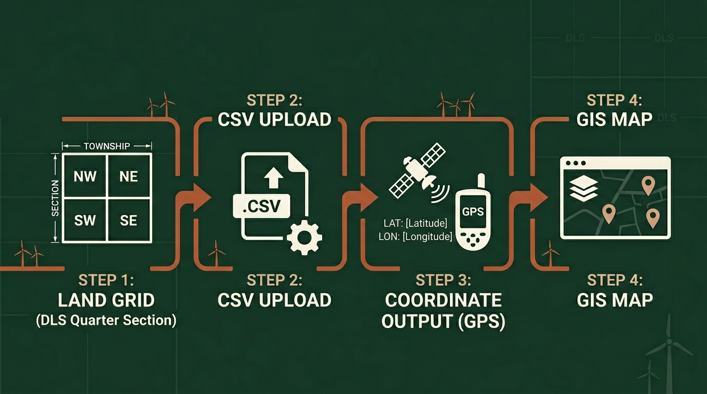
All of these tasks start with the same thing: converting DLS quarter section references to coordinates, accurately and in bulk. Renewable energy site selection in Alberta runs on the Dominion Land Survey grid, and if you work in wind or solar development, you already know the notation. The challenge is working with it efficiently at project scale.
Why Renewable Energy Projects Depend on DLS Precision
Alberta's provincial policy requires agricultural impact assessments for renewable energy projects on land classified as Class 1, 2, or 3 soil capability. The assessment identifies every affected parcel by its legal land description. A wind project spanning 30 quarter sections means 30 individual DLS references in the assessment - each one must be correct, because AUC filings and supporting land records rely on exact parcel references.
Private land leases reference quarter sections directly. A lease for NW-14-12-22-W4 - northwest quarter, Section 14, Township 12, Range 22, West of the 4th Meridian - is enforceable because it maps to an exact 160-acre parcel near Vulcan, Alberta. A vague description like "the field northwest of the county road" is not registrable against a title. The DLS system is the legal framework that makes these agreements precise.
Surface rights negotiations, setback calculations from occupied dwellings, and transmission interconnection applications all use the same notation. When the AUC reviews a project application under the Hydro and Electric Energy Act, the facility description identifies every affected parcel by DLS reference.
How Wind and Solar Developers Use Quarter Section Grids
Defining a Project Footprint
A typical Alberta wind project covers portions of 20 to 60 quarter sections. Each turbine pad occupies a fraction of a quarter section, but the associated infrastructure - access roads, cable trenches, substation, and laydown areas - extends across adjacent parcels. The project footprint is the union of all affected quarter sections.
For a 12-turbine project near Claresholm in southern Alberta, the lease schedule might list:
- NE-16-10-26-W4
- NW-16-10-26-W4
- SE-21-10-26-W4
- SW-21-10-26-W4
- NE-20-10-26-W4
- SE-20-10-26-W4
- NW-15-10-26-W4
- NE-15-10-26-W4
- SW-22-10-26-W4
- SE-22-10-26-W4
- NW-22-10-26-W4
- NE-22-10-26-W4
That's 12 quarter sections across four contiguous DLS sections in Township 10, Range 26, West of the 4th Meridian - open prairie with strong, consistent winds. Converting all 12 to GPS coordinates confirms the project boundary and generates the waypoints needed for field surveys.
Enter these into Township Canada's batch converter as a CSV list (Business plan required), and you get GPS coordinates for every parcel centre in seconds. Download the results as KML for Google Earth review or Shapefile for import into ArcGIS or QGIS. See the batch conversion guide for step-by-step instructions on processing bulk location files.
Setbacks and Road Allowances
Alberta's Rule 012 (Noise Control) and municipal setback bylaws require minimum distances between turbines and occupied dwellings. These distances are measured from the turbine pad - identified by its LSD or quarter section - to the nearest dwelling. Knowing the precise GPS coordinates for each quarter section centre helps engineers calculate setback compliance before finalizing turbine placement.
Road allowances in the DLS grid run along section lines (east-west) and range lines (north-south). These 66-foot-wide corridors affect access road planning and cable routing. The DLS grid map on Township Canada's interactive map shows section boundaries overlaid on satellite imagery, making road allowances visible during the desktop screening phase.

Real Workflow: From Quarter Sections to GPS for an Agricultural Impact Assessment
A solar developer in southern Alberta is preparing an agricultural impact assessment for a 200 MW project near Taber. The project area covers 34 quarter sections across Townships 11 and 12, Ranges 16 and 17, W4. The assessment must identify each parcel's soil classification, current agricultural use, and reclamation plan.
Here's the workflow:
- List all affected quarter sections from the lease schedule and project layout drawings
- Upload the list to the batch converter - paste the 34 DLS descriptions into the batch input or upload a CSV file, then convert
- Export to KML and Shapefile - download the results using Township Canada's export tools on a Business plan
- Import into GIS - load the KML into Google Earth for a quick visual check, and the Shapefile into ArcGIS for the formal soil classification overlay
- Cross-reference with AGRASID - overlay the GPS-located parcels against Alberta's Agricultural Region of Alberta Soil Inventory Database to identify Class 1–3 soils
- Generate the assessment map - the GIS output becomes the spatial component of the agricultural impact assessment submitted to the AUC
The entire conversion step - from a column of DLS references to GPS-located parcels in a GIS-ready format - takes under a minute with batch processing. Without it, each quarter section would need to be looked up individually, coordinates copied manually, and formatted for GIS import.
Using the Township Canada API for Project Management Tools
For developers building internal project management or land acquisition tools, the Township Canada API converts DLS descriptions to GPS coordinates programmatically. A POST to the Batch API endpoint converts up to 100 legal land descriptions per request, returning GeoJSON with coordinates and boundary polygons.
A wind developer's internal land tracking system can call the API to geocode every parcel in its database, keep coordinates current as new leases are signed, and generate map views for project managers - without manual conversion steps. Batch API plans start at 1,000 requests; see the API page for tier pricing. See the API integration guide for authentication and endpoint details.
Example: A 340-Quarter-Section Solar Screen
Consider a solar developer in the County of Forty Mile in southeastern Alberta preparing an agricultural impact assessment for a large proposed solar project. The project area spans 340 quarter sections across multiple townships - a mix of dryland crop, irrigated crop, and native grassland parcels.
The land team has a spreadsheet of DLS descriptions from signed lease agreements. The environmental consultant needs GPS coordinates for every parcel to run the soil classification analysis and generate the assessment maps for the AUC submission.
Using Township Canada's batch converter, the team uploads all 340 descriptions in a single CSV file. The converter returns GPS coordinates and boundary data for every parcel. The results export as a Shapefile and import directly into ArcGIS, where the consultant overlays them against AGRASID soil data and Alberta Merged Wetland Inventory layers.
The conversion and export take less than two minutes. The alternative - looking up each quarter section individually and transcribing coordinates - would take the better part of a week.
Getting Started
If you're working on renewable energy site selection in Alberta, start with the Alberta legal land description converter for individual quarter section lookups. For project-scale work with dozens or hundreds of parcels, the batch converter on a Business plan handles the volume and provides KML, Shapefile, and GeoJSON exports for direct GIS import.
For a deeper look at how the DLS grid works and why it matters for renewable energy development, see the DLS system guide and the renewable energy industry page.
Enter NE-16-10-26-W4 into the Township Canada converter to see a quarter section in southern Alberta's wind corridor near Claresholm - an area where many of the province's largest wind projects are sited.