By Township Canada
Saskatchewan Oil Well Location Lookup: Finding Wells by DLS Legal Description
Look up Saskatchewan oil and gas wells by LSD or quarter section on the DLS grid. Wells, pipelines, and facilities on one map, no portal-hopping required.
A landman in Weyburn is reviewing a surface lease renewal. The lease references LSD 14-10-7-13-W2, a 40-acre parcel just west of the city in the heart of the Bakken light-oil fairway. Before the lease goes back to the landowner for signature, the landman needs to confirm exactly which licensed wells sit on that quarter section, whether any pipeline right-of-way crosses the parcel, and what facilities are nearby. The well registry is one browser tab. The pipeline viewer is another. The DLS grid is a third. None of them talk to each other, and the morning is half gone.
That workflow just got shorter. Township Canada's Saskatchewan Wells, Pipelines, and Facilities layers now place the province's 65,000+ licensed wells on the same DLS grid you already use for legal land descriptions. One map, one search, the full picture.
What the SK Energy Layers Show
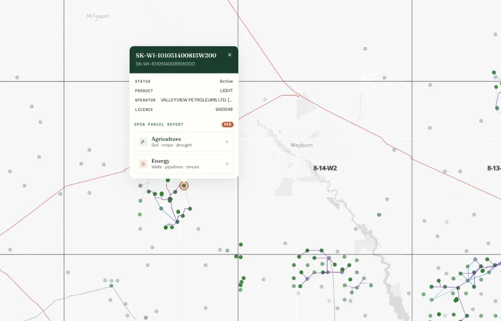
The Saskatchewan well, pipeline, and facility layers render as PMTiles on top of the DLS survey grid with satellite imagery underneath. Toggle them on from the map layers panel and every licensed wellbore in the province appears, colour-coded by status.
Each well point carries its UWI in the standard SK format (e.g., 101/14-10-7-13-W2/00), licence status from the Saskatchewan Ministry of Energy and Resources (active, suspended, abandoned, reclaimed), substance type (crude oil, natural gas, multiphase), and the licensee operator name. Click any well to open the detail popup.
The Pipelines layer draws gathering lines, trunk lines, and flow lines as coloured line work with licence number, substance, and status on hover. The Facilities layer marks batteries, compressor stations, and other surface infrastructure. All three layers compose on the same map: wells, their tie-in lines, and the destination battery render together once you have the SK filter applied.
For multi-province work along the Alberta-Saskatchewan border, toggle both provinces on at once. A pipeline corridor that crosses from W4M into W3M renders continuously.
Surface Lease Review: A Weyburn-Area Example
Back to that surface lease. Enter 14-10-7-13-W2 into the Saskatchewan legal land converter. The map centres on the parcel with the LSD outline drawn on the DLS grid. That location sits in Township 7, Range 13, West of the 2nd Meridian, inside the Weyburn-Midale CO2-EOR unit footprint.
With the SK Wells layer enabled, every licensed wellbore that surfaces inside that LSD and the adjacent quarter sections appears as a pin. Toggle on Pipelines to see which lines connect those wells to the nearest battery. Toggle on Facilities to identify the battery itself. The landman now has, on one screen, what used to require three separate tools and most of a morning.
From there, the workflow branches:
- Field dispatch: Copy the GPS coordinates from the parcel centre and send them to the field crew's navigation system. No manual conversion needed.
- Batch processing: If the lease review covers 200 LSDs across the Weyburn unit, upload the full list as a CSV to the batch converter. Output includes GPS coordinates, province, and municipality for each record.
- Export: Pull the well locations and parcel boundaries as KML for Google Earth, Shapefile for ArcGIS, or CSV for the land database.
How Saskatchewan's DLS Grid Differs from Alberta's
If you've worked Alberta wells, the DLS notation looks familiar: LSD-Section-Township-Range-Meridian. The structure is identical. What changes is the meridian reference.
Alberta runs from W4M (eastern Alberta, near the Saskatchewan border) through W5M (central) to W6M (western Alberta at the BC border). Saskatchewan runs from W1M (eastern Saskatchewan, near the Manitoba border) through W2M (central, anchored near 102°W along the Manitoba border) to W3M (western Saskatchewan).
In practice, this means two things for SK O&G work.
First, the meridian split is cleaner. The producing Williston Basin, from Estevan north through Weyburn to the Bakken trend, sits almost entirely on W2M. The WCSB-fringe heavy oil around Lloydminster and the west-central SK production references W3M. Unlike Alberta, where the W4M/W5M boundary cuts through the middle of major producing areas, SK's meridian boundary doesn't bisect a single major play. If you're working Williston Basin files, it's W2M. If you're working Lloydminster heavy oil, it's W3M.
Second, there's no W5M correction complexity. Alberta's W5M carries a well-known set of irregularities near the range boundaries (short sections, irregular LSDs) that catch people doing batch conversions. Saskatchewan's DLS grid has its own edge cases, but the meridian-to-meridian transition is more straightforward. The Saskatchewan quarter section guide covers the meridian-by-meridian breakdown in detail.
SK well licences reference LSDs in the same format as Alberta's AER filings. A SK well at LSD 14-10-7-13-W2 reads the same way: Legal Subdivision 14, Section 10, Township 7, Range 13, West of the 2nd Meridian. The regulatory body is different (Saskatchewan's Ministry of Energy and Resources, not the AER), but the addressing system is the same DLS grid.
Cross-Referencing Wells with Crown Tenure and Soil Data
Surface lease negotiations in Saskatchewan often involve more than just the well inventory. The same map that shows wells and pipelines can also show Crown petroleum and natural gas (PNG) tenure, mineral tenure, and soil survey data.
Toggle the petroleum tenure layer to see which Crown dispositions overlap the parcel. Are there active leases, exploratory permits approaching expiry, or freehold minerals that change the negotiation? The Township Canada parcel report for any SK LSD now includes tenure intersections for both PNG and mineral dispositions.
For agricultural land, the SK soil survey and ag crown land layers compose on the same map. A wellsite or pipeline right-of-way under negotiation sits in a specific soil capability class, and the landowner's compensation claim may reference that productivity. Having the soil layer visible alongside the energy layers puts both sides of the negotiation on the same screen.
The SK, BC, and Manitoba layers launch post covers the full provincial inventory, including the agriculture layers and the AI assistant's multi-province tenure queries.
Getting Started
The SK Wells, Pipelines, Facilities, and Oil-Gas Pools layers are part of the Energy Bundle on the Business tier. If you already subscribe to the Energy Bundle, the SK layers are live in your map layers panel today. If not, the bundle stacks on your existing plan. See the pricing page for the breakdown.
For a detailed walkthrough of the SK energy layers, including the worked example and layer-by-layer breakdown, see the Saskatchewan oil well DLS map layer guide.
To try it now: enter 14-10-7-13-W2 into the Saskatchewan legal land converter and toggle on the SK Wells layer. That Weyburn-area LSD, plus every licensed well around it, will be on your screen in seconds.