By Township Canada
Township Canada Product Update - May 2026
May 2026: the Agriculture and Energy Bundles, one-click Parcel Reports, the new Ask Township AI assistant, AER layers live on the map, a measure-and-draw toolbar with saved boundaries, and the field app on iOS and Android.
May was the most active shipping month in Township Canada's history. The Agriculture and Energy Bundles launched, putting farmland productivity, soil, crop history, wells, pipelines, and Crown tenure data across AB, SK, BC, and MB in one place. One-click Parcel Reports went live, the new Ask Township assistant arrived, the energy layers that power the bundles are now drawn on the map, and the field app launched on iOS and Android.
Here's everything that shipped.
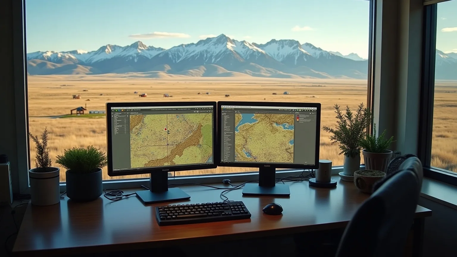
One-click Parcel Reports
Go to /app/parcel/[lld] for any legal land description and you get a full data report on that quarter section: soil classification, oil-and-gas activity context, crop and land-use history, and location details, all in one view with a PDF export. Type in NW-7-13-21-W4 and instead of a pin on a map, you get everything known about that parcel from official government datasets.
Soil Landscapes of Canada (SLC v3.2) is now in every report. Outside Alberta, where AGRASID 4.1 soil data covers the province at LSD resolution, parcel reports fall back to the AAFC Soil Landscapes of Canada dataset for soil order classification. If you're looking at a quarter section in Saskatchewan, Manitoba, or BC, the soil context travels with you, colour-coded by order, with a popover for interpretation. This rounds out the agronomic picture for every parcel across the Prairies.
The Agriculture and Energy Bundles
Two new bundles shipped. The Agriculture and Energy Bundles give you the data that drives land decisions, on the same search and map you already use. Full details are in the launch post, but here's the short version:
- Agriculture Bundle gives you the LSRS productivity score (0 to 100, per quarter section), AGRASID soil subgroup and drainage class, the AAFC Annual Crop Inventory (five-year rotation, dominant crop, diversity index), a current drought index, and the single factor capping the productivity score. Alberta is covered at LSD resolution; crop and drought layers cover the Prairies and BC.
- Energy Bundle gives you AER wells (operator, licence status, abandoned and orphan flags), AER pipelines (licence, substance, diameter), AER facilities, a Petrinex 12-month production summary (oil, gas, and water volumes), and Crown tenure zones, all plotted on the DLS grid with satellite imagery.
Both bundles add a Parcel Report overview tab with a plain-English headline summarizing the agronomic and energy context for the parcel, plus a branded PDF export you can hand to a client or attach to a regulatory file. Add either one as an add-on from your account dashboard (see pricing).
Ask Township: a new AI assistant
Ask Township, our AI assistant, is live. Open it from the button in the bottom-right corner of the app and ask in plain English. It can convert a legal land description to coordinates and give you driving directions between two parcels. On Pro and Business it also validates a description's format. On Business it also batch-converts a list of locations and optimizes a multi-stop route. On all plans it answers questions about features, pricing, and the legal-description systems themselves. What it can do scales with your plan, and so does the daily message allowance: 30 messages a day on Starter, 200 on Pro, and unlimited on Business.
Energy layers, now on the map
The data behind the Energy Bundle is no longer report-only. AER wells, pipelines, and facilities now render directly on the DLS grid, each with its own symbology and a theme-aware legend that stays readable in light and dark mode. Unified search returns wells and operators alongside parcels, so you can jump straight from a search result to its spot on the map. One-click layer presets switch the map between liability, production, and tenure views without hunting through a layer list.
Several government datasets came online in May to power these features:
- AER pipelines and facilities (ST76, ST102) join AER wells on the map, with licence, operator, substance, diameter, and status, plus abandoned and orphan flags on wells.
- Petrinex well production provides a per-well 12-month rollup of oil, gas, and water volumes behind the Energy Bundle production summary.
- LSRS Productivity Score delivers per-quarter-section land productivity ratings (Alberta v1), built on AGRASID 4.1 and AAFC's Land Suitability Rating System. This is the foundation of the Agriculture Bundle score.
- AAFC Annual Crop Inventory (v5) adds national crop raster data plus a per-quarter-section rollup of dominant crop, five-year rotation, and diversity index, covering the Prairies and BC.
Measure, draw, and save boundaries
A new map toolbar brings measuring and drawing into one place. Measure a distance or an area for free, on any plan. On Pro, switch to draw mode, click the corners of a property boundary, and the toolbar gives you its area, perimeter, and corner coordinates. Name it and save it to a Boundaries project, then export it: a PDF map and report on Pro, or GeoJSON, KML, Shapefile, and DXF on Business.
The field app, now on iOS and Android
The Township Canada field app is available on iOS and Android. Search, map, and navigate to LSD and DLS locations from the field, with the same legal-description coverage as the web app. It's included with every paid plan (Starter, Pro, Business) at no extra cost: just download the app and sign in with your Township Canada account (see pricing). Download from the App Store or Google Play.
Built to stay current
The datasets behind every report and map layer now refresh automatically on each source's publishing schedule. Wells, production, soil, crop, and tenure data stay current instead of going stale between manual updates, so the parcel you look up tomorrow reflects the latest the agencies have published.
What's coming
Ask Township, connected to your bundle data. A private alpha lets the assistant answer questions about a specific parcel's wells, soil, crop history, drought status, and tenure, grounded in the same datasets behind your reports. It's rolling out gradually to Agriculture and Energy Bundle subscribers.
Land Portfolio Manager. The spec is done. The Portfolio Manager lets you track owned or watched parcels with running data updates, productivity-score changes, well activity, and tenure status, rather than running one-off lookups. Build starts next.
Alberta Crown dispositions overlay. Crown surface and mineral disposition boundaries are the next data layer. The spec is written; ETL build and map integration follow.
We ship new features based on what users ask for. If something's missing from your workflow, email us at hello@townshipcanada.com. We read every note.