Energy API for Oil and Gas Developers in Canada
Programmatic access to Canadian energy parcel data: well sites, Crown tenure, pipelines, and production via the Township Canada Energy API.
Energy API for Oil and Gas Developers in Canada
An oil and gas developer building a land management system needs well counts, Crown tenure status, and pipeline proximity for a given Legal Subdivision. The underlying data exists across multiple regulatory sources: AER ST37 for wells, AER ST76 for pipelines, provincial Crown tenure registries for PNG and mineral rights. Pulling from each source and keeping it current is a project in itself.
The Township Canada Energy API provides this data through a single authenticated endpoint. Send an LSD legal land description in Alberta, Saskatchewan, or Manitoba, and the response returns wells, pipelines, facilities, Crown tenure intersections, and 12-month production for that parcel, all in one call.
What the API returns
A request to the Energy API with a legal land description such as 7-10-13-9-W4 returns a structured response with these sections:
Summary: total wells on the parcel, broken down by status (active, suspended, abandoned, orphan), plus facility and pipeline counts.
Wells: individual provincial well records within the Legal Subdivision, including orphan and abandoned flags. The report API supports Alberta, Saskatchewan, and Manitoba; available datasets vary by province.
Pipelines: pipeline crossings through the parcel with substance, status, pressure class, H2S content, and segment length. Pipeline report data covers Alberta and Saskatchewan.
Facilities: AER-licensed facilities on or adjacent to the parcel (Alberta and Saskatchewan).
Crown tenure: intersecting Crown PNG and mineral dispositions in Alberta, Saskatchewan, and Manitoba, where published expiry dates are available.
Production: trailing 12-month oil, gas, water, and condensate volumes.
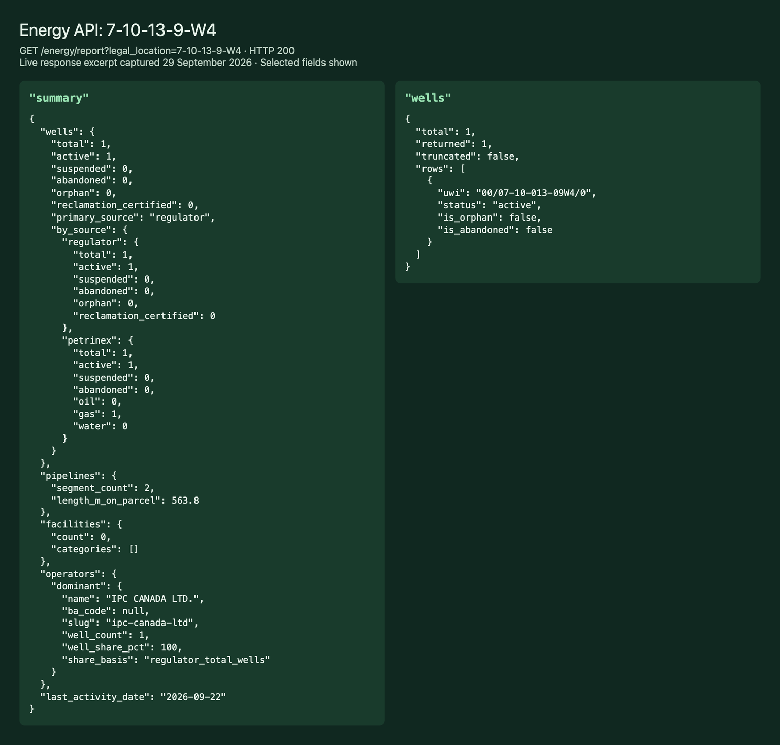
Response excerpt captured on September 29, 2026. Collection sections use envelopes with total, returned, truncated, more, and rows.
A practical scenario
A pipeline company is building an internal tool that screens proposed route segments for nearby energy infrastructure. Without the API, this means querying AER OneStop for wells, pulling pipeline data from a separate ST76 download, cross-referencing tenure registries, and reconciling all of it against Legal Subdivision boundaries.
With the Energy API, the tool sends the Legal Subdivision for each segment (for example, 06-32-048-07W5) and gets wells with abandonment status, pipeline crossings with substance and pressure class, and active Crown tenure with expiry dates in one response. One integration replaces four, and the data refreshes on Township Canada's update cycle rather than requiring a manual download.
Authentication and access
The Energy API uses API key authentication over HTTPS. You generate a key from your Township Canada account, include it in the X-API-Key header, and make requests against the API endpoint.
Three tiers are available, each with a monthly request quota and rate limit:
| Tier | Monthly cost | Requests per month | Rate limit |
|---|---|---|---|
| Build | $50 CAD | 500 | 1 req/s |
| Scale | $250 CAD | 5,000 | 2 req/s |
| Enterprise | $1,250 CAD | 50,000 | 5 req/s |
All amounts are in Canadian dollars. Annual billing (pay for 10 months, get 12) is available on each tier.
The Energy API is a standalone product, purchased independently of the web app subscription or the Energy Bundle add-on.
Coverage
| Dataset | AB | SK | BC | MB |
|---|---|---|---|---|
| Wells | Yes | Yes | No | Yes |
| Pipelines, facilities, production | Yes | Yes | No | No |
| Crown PNG and mineral tenure | Yes | Yes | No | Yes |
| CCS pore space and geothermal tenure | Yes | No | No | No |
BC requests currently return 400 bc_not_supported. The web app has separate BC coverage. Manitoba report coverage includes wells and Crown tenure.
Related resources
- Legal land descriptions for oil and gas: how the DLS system works in energy workflows
- LSD: Legal Subdivision: the addressing unit for well locations and parcel reports
- UWI to GPS: the O&G developer's guide: parsing Unique Well Identifiers and converting at scale
- Pricing: Energy API tier details and annual billing
Get started
Generate an API key from your Township Canada account and make your first request with a Legal Subdivision you already know. The response structure is consistent across supported provinces, with explicit gaps where a dataset is unavailable.
FAQ
What data formats does the Energy API return? The API returns JSON. Wells, pipelines, facilities, and tenure are collection envelopes containing rows and counts; summary and production are objects.
Can I query by GPS coordinates instead of a legal land description? The Energy API report accepts LSD legal land descriptions. If you have GPS coordinates, use the Township Canada Search API to resolve them to a legal land description first, then pass that to the Energy API.
How often is the underlying data refreshed? Wells, pipelines, facilities, and production data update monthly from AER and Petrinex sources. Crown PNG and mineral tenure data updates weekly.
Related Articles
Legal Land Descriptions for Oil and Gas
How oil and gas professionals use DLS, LSD, NTS, and UWI to identify well locations, plan pipeline routes, and meet AER filing requirements across western Canada.
The Dominion Land Survey (DLS) System Explained
How the DLS grid divides Western Canada into townships, ranges, sections, and quarter sections. History, format, examples, and conversion guide.
Understanding Legal Subdivisions (LSDs)
How LSDs subdivide a DLS section into 16 numbered parcels. LSD numbering, format, examples, and how to convert LSDs to GPS coordinates.