Manitoba River Lot to GPS - Locate and Convert a River Lot Description
How to find a Manitoba river lot like River Lot 52, Parish of St. Andrews on a map and convert the river lot description to GPS coordinates.
Manitoba River Lot to GPS: How to Locate and Convert a River Lot Description
A title document or an old survey plan near Winnipeg gives you a line like River Lot 52, Parish of St. Andrews and nothing else - no township, no range, no street address, no map pin. Plug that into a standard prairie converter and you get an error, because a river lot is not a point on the township grid. This guide shows how to read a Manitoba river lot description and turn it into GPS coordinates.
What a river lot description actually tells you
A Manitoba river lot description has exactly two parts that matter for locating it:
- The lot number - a sequential parcel number, such as
52. - The parish - the settlement belt it belongs to, such as the Parish of St. Andrews.
The catch is that the lot number means nothing on its own. Numbering restarts in every parish, so lot 52 in one parish and lot 52 in the next are two different parcels several kilometres apart on the Red River. The parish is what anchors the number to a real stretch of riverbank. Drop the parish from your search and the result is ambiguous at best.
🗺️ Diagram placeholder: Two adjacent parish belts along the Red River, each with its own Lot 52 highlighted, showing that the lot number repeats per parish.
Why a river lot will not convert like a quarter section
A DLS quarter section such as a Range/Township/Section reference is effectively a coordinate you can calculate - the grid is regular, so the description resolves to a square cell by arithmetic. A river lot does not work that way. It is a hand-surveyed strip running back from the river, recorded against a specific parish plan, and the only way to place it is to look it up in that survey record. That is also why a DLS to GPS converter returns nothing useful for a river lot - it is reading for a grid cell that the river lot system never defined. For the full background on the system, see Manitoba River Lots and Parish Lots Explained.
Step by step: River Lot 52, Parish of St. Andrews to GPS
- Confirm both parts. Read the lot number and the parish off the document. Township Canada also accepts each parish as a two-letter code, so the Parish of St. Andrews is
AD. - Enter the description. Type it as written,
River Lot 52, Parish of St. Andrews, into the Township Canada search bar. Shorter forms find the same parcel:RL 52 St. Andrews, or the codeRL-52-AD(RLfor river lot, then the lot number, then the parish code). - Read the pin and the shape. The map centres on the parcel. The long, narrow footprint running back from the Red River is itself a check - if you see a square block instead of a ribbon, you have matched a DLS parcel by mistake.
- Copy or export the coordinates. Take the latitude and longitude for a field tablet, or export the parcel as KML, Shapefile, or GeoJSON for GIS and title work.
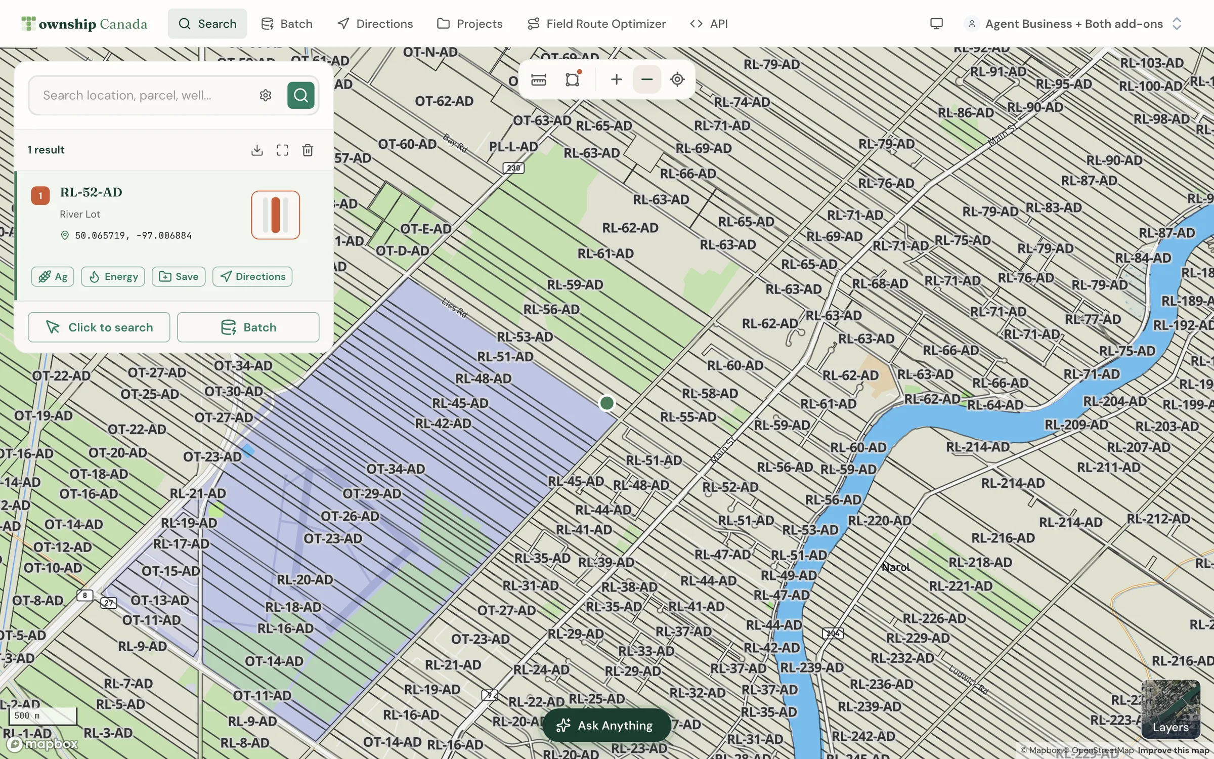
What the result looks like
The Parish of St. Andrews runs along the Red River north of Winnipeg, around Lockport and the St. Andrews area - roughly 30 km downstream of the city centre, near 50.1°N, 96.9°W. Township Canada returns the centroid coordinates for the specific lot plus its boundary polygon, so you get the exact parcel rather than the parish as a whole. The same lookup works for the other historic belts - St. Clements, Kildonan, St. Boniface, and the Assiniboine River parishes west of the city.
Common mistakes to avoid
- Searching the lot number alone. A lot number with no parish is ambiguous - always include the parish.
- Forcing it into the DLS grid. River lots have no township, range, or section; do not try to translate them into a quarter section.
- Wrong St. Andrews. There are St. Andrews place names in several provinces. Confirm you are working in Manitoba's Red River belt before trusting a pin.
For river lots alongside the rest of the province's land - the DLS grid that covers most of Manitoba - see the Manitoba land description guide and the legal land description lookup. For a fuller walk through the parish system, the Manitoba river lot converter guide covers parishes and history in depth.
Try it now
Enter RL-52-AD (River Lot 52, Parish of St. Andrews) into Township Canada to drop the parcel on the Red River north of Winnipeg and read its GPS coordinates. Paste a different lot or parish to locate any river lot in the Winnipeg region the same way.
Related Articles
DLS to GPS Converter - Convert Dominion Land Survey to Coordinates
Convert DLS (Dominion Land Survey) descriptions to GPS coordinates. Supports sections, quarter sections, and LSDs across Alberta, Saskatchewan, Manitoba, and BC.
Legal Land Description Lookup - Find Any Land Parcel in Canada
Look up any Canadian legal land description and get GPS coordinates, map location, and parcel details. Supports DLS, LSD, NTS, and all provincial systems.
River Lot Converter for Manitoba - Convert River Lots to GPS
Convert Manitoba river lot descriptions to GPS coordinates. Understand the Red River lot system and how to look up river lots in Township Canada.