Legal Land Descriptions for Water Resources - Licences, Irrigation Districts, and Intake Planning
How water licence applicants, irrigation districts, and intake planners use DLS and NTS legal land descriptions for Alberta Water Act and BC Water Sustainability Act filings.
Legal Land Descriptions for Water Licensing and Water Resource Planning
Every water licence application in Alberta references a DLS quarter section. Every BC water licence application references an NTS grid cell. Irrigation district managers, municipal water intake planners, and agricultural producers filing for water diversion registrations under the Alberta Water Act all identify their water source locations, points of diversion, and areas of use by legal land description.
Alberta Environment and Protected Areas (AEPA) administers thousands of active water licences and registrations under the Water Act, each tied to a DLS location. BC's Water Sustainability Act requires NTS map sheet references for licence applications outside the Lower Mainland. Converting between these legal descriptions and GPS coordinates is a routine step in every water licence filing, irrigation district planning cycle, and municipal water intake assessment.
How Water Licensing Uses Legal Land Descriptions
Alberta Water Act Applications
The Alberta Water Act requires a legal land description for every point of diversion, place of use, and works location in a licence or registration application. A farmer applying for a water diversion registration to fill a dugout from a spring identifies the dugout location as a DLS quarter section or LSD. A municipality applying for a licence to draw water from a river identifies the intake structure by its LSD address.
The AEPA approval process cross-references the legal land description against existing allocations in the same watershed. If two licence applications reference adjacent quarter sections drawing from the same aquifer or watercourse, the department evaluates cumulative impact based on those DLS locations. A wrong legal description on a water licence application can delay processing by weeks while the location is corrected and the allocation reassessed.
For a detailed explanation of how the DLS grid is structured, see Township, Range, and Meridian Explained.
BC Water Sustainability Act Applications
In British Columbia, water licence applications under the Water Sustainability Act identify the source location using NTS map sheet references for areas outside the established DLS grid. A forestry company applying for a water licence to supply a remote camp on Vancouver Island identifies the creek diversion point within NTS sheet 092F/07. An agricultural operation in the Okanagan applying for an irrigation licence references its intake structure within the NTS grid.
Converting an NTS reference to GPS coordinates confirms the diversion point location before field survey and helps the applicant prepare the required map. See NTS to GPS Converter for a full walkthrough, or use the BC NTS converter directly.
Real-World Scenarios
Scenario 1: Irrigation District Water Allocation Review
An irrigation district in southern Alberta is reviewing allocations across its service area for the upcoming growing season. The district manages water delivery to several hundred irrigators, each identified by the DLS quarter sections they irrigate. A pivot irrigator at NW 18-010-19W4 draws from a lateral canal that serves a block of contiguous quarter sections south of the Bow River.
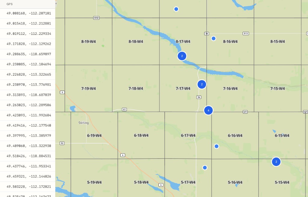
The district office needs a current map showing every irrigated quarter section with its allocation volume and delivery lateral for the annual report to AEPA. Enter the full list of quarter sections into the batch converter and export the GPS coordinates as a CSV for import into the district's mapping system. The result shows every irrigated parcel on satellite imagery, confirming which fields are adjacent to which canals.
Scenario 2: Municipal Water Intake Licence Application
A town in central Alberta is applying to AEPA for a water licence to construct a new intake on the North Saskatchewan River. The application form requires the legal land description of the proposed intake structure, the pipeline route from the river to the treatment plant, and the distribution area.
The intake location is at LSD 03-18-039-27W4, a 40-acre parcel on the riverbank near Ponoka. The pipeline route crosses three quarter sections between the river and the treatment plant. The engineer converts all four DLS descriptions to GPS coordinates using Township Canada to prepare the location map required for the application package.
Use the LSD finder to pinpoint the 40-acre parcel where the intake structure will sit. The surrounding quarter sections are visible on the map view, showing the pipeline route context without switching to a separate mapping tool.
Scenario 3: PFRA Dugout Construction Filing
A cattle operation near Hanna, Alberta needs a new dugout for livestock watering. Under the Water Act, dugouts below a certain storage volume may qualify for a traditional agricultural use registration rather than a full licence, but the filing still requires a legal land description identifying the proposed construction site.
The proposed dugout location is on SE 22-031-14W4, a quarter section of native grassland in the Special Areas. The rancher enters the quarter section into Township Canada to confirm the GPS location, then includes the coordinates in the registration filing alongside the DLS description. The map view shows the surrounding terrain and nearby water features that the Water Act registrar will review for cumulative impact assessment.
For individual lookups like this one, use the quarter section finder.
Provincial Water Licensing Systems
Alberta
Alberta's Water Act framework uses DLS descriptions for all licence and registration locations. The three main filing types are:
- Water licences: Required for any diversion of surface water or groundwater above domestic thresholds. The legal land description identifies the point of diversion, the works (intake, pipeline, reservoir), and the area of use.
- Traditional agricultural registrations: For agricultural users who diverted water before 1999. Registered by DLS quarter section.
- Temporary diversion licences: Short-term water use for construction, drilling, or dust suppression. The legal land description identifies both the water source and the project site.
British Columbia
BC's Water Sustainability Act uses NTS grid references for water source identification in areas outside the DLS grid. The BC NTS converter resolves any NTS map sheet reference to GPS coordinates for field surveys and application maps.
Saskatchewan
Saskatchewan's Water Security Agency administers water rights using DLS legal land descriptions. Irrigation allocations, municipal licences, and industrial water rights all reference DLS quarter sections in the W2M and W3M meridian zones. See Saskatchewan Quarter Section Guide for how DLS notation works in that province.
How Township Canada Handles Water Resource Workflows
Water licence location verification: Enter any DLS quarter section or LSD from a water licence application to confirm the location maps to the correct watercourse, aquifer, or field. Use the quarter section finder for individual lookups.
Irrigation district mapping: Convert a full list of irrigated quarter sections to GPS coordinates for annual reporting, allocation reviews, and infrastructure planning. The batch converter handles large lists on a Business plan.
BC water licence applications: Convert NTS grid references from BC water licence filings to GPS coordinates for application maps and field surveys. Use the BC NTS converter or the NTS to GPS converter.
Municipal intake planning: Convert the DLS descriptions of proposed intake structures, pipeline routes, and distribution areas to GPS coordinates for engineering drawings and regulatory submissions. Use the LSD finder for parcel-level precision.
Multi-parcel export: For water resource projects spanning many quarter sections, export GPS results as CSV, KML, or GeoJSON for import into engineering and GIS software. Export formats are available on the Business plan.
Try It with a Water Licence Location
Enter NW-18-010-19W4 into the Township Canada converter to see a quarter section in southern Alberta's irrigation country near the Bow River Irrigation District. The result shows the parcel on the DLS grid with GPS coordinates for the centre and corners, ready for a water licence application form or an irrigation district allocation map.
For individual quarter sections, use the quarter section finder. For BC water licence applications using NTS references, try the BC NTS converter. For irrigation district lists covering hundreds of parcels, the batch converter processes them all on a Business plan.
Related Articles
AAFC Crop History: Look Up 5 Years of What's Been Grown on Any Quarter Section
AAFC's Annual Crop Inventory shows dominant crop per pixel since 2009. Township Canada aggregates it to a 5-year rolling per-quarter summary with rotation and diversity score.
AER Facilities Map: 8 Categories from 40+ Petrinex Sub-codes
Township Canada collapses AER ST102 facility sub-codes into 8 clean categories (battery, gas plant, compressor, disposal, etc.) so the catalog UI stays readable across the full Alberta dataset.
AER Pipelines Map: Visualize Alberta Oil and Gas Pipelines on the DLS Grid
Township Canada renders every AER-licensed pipeline as a line layer with mid-point labels. For operators, integrity teams, and right-of-way planning.