By Township Canada
Look Up a UWI and Map the Well: From Identifier to Wellhead in Alberta
Turn a UWI into GPS coordinates and a well on the map. Why the UWI names the bottom hole, how to find the wellhead, and where status fits in.
A land technician reconciling a well list before year end usually starts with a column of Unique Well Identifiers from an AER licence list or a Petrinex export. For each one, the questions are the same: where is the well, which quarter section is it on, and what state is it in. The UWI answers the first question only partly, and the part it answers is easy to misread.
This post walks through a single UWI in Township Canada, from the identifier to the well on the map, and then scales the same steps to a full list.
What a UWI contains
A DLS-format UWI has three parts. Take 100/06-32-048-07W5/00:
100is the prefix: the survey system and the location exception code. The exception code tells apart wells whose locations fall in the same LSD. Exports from AER systems often write a two-character version, as in00/06-32-048-07W5/0.06-32-048-07W5is the location: LSD 6, Section 32, Township 48, Range 7, west of the 5th Meridian.00is the event sequence, which separates later drilling or completion events at the same location.
The location in a UWI is the bottom-hole LSD, where the wellbore ends, not the wellhead. For a vertical well the two are the same LSD. For a directional or horizontal well, the wellhead can sit in a different LSD, section, or township from the one the UWI names. That distinction decides which coordinates you should hand to a field crew. The UWI reference page covers the NTS-format UWIs used in northeast BC.
Search the UWI as a location
Paste the UWI into the Township Canada search box. Either prefix form works. Township Canada reads the location part and returns the LSD it names: 100/06-32-048-07W5/00 and 00/06-32-048-07W5/0 both resolve to 6-32-48-7-W5, with its centre at 53.183303, -114.991868.
From the LSD you also get the quarter section. LSD 6 sits in the southwest quarter of its section, so the quarter for this well's records is SW-32-48-7-W5. If you need to check how LSD numbers fall inside a section, the LSD finder lays out the grid.
Keep in mind what this result is: the centre of the bottom-hole LSD. It is the right answer for "which LSD does this UWI name", and an approximate one for "where is the lease road".
Search the UWI as a well
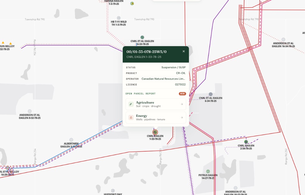
For Alberta wells, Township Canada can also look the UWI up in the AER well list itself. Open the search sources and turn on AER Wells, which matches by UWI, well name, or licence number. A UWI search then returns the well record: well name, licence number, licence status, and fluid. The map flies to the well and highlights it.
The well's pin is the wellhead. Township Canada places wells by their surface hole, which is where a crew drives to and where a surface agreement applies. When the pin sits in a different LSD from the one in the UWI, that is not a data error. It is a deviated or horizontal well whose bottom hole is elsewhere.
Read the well on the map
With the Energy add-on, the Wells layer plots licensed wells across Alberta, Saskatchewan, British Columbia, and Manitoba on the DLS grid. Selecting a well opens a popup with its UWI, well name, status, product, operator, and licence number, plus links to the parcel report for that location.
For Alberta wells, the well sidebar also opens a subsurface view that shows the surface and bottom hole, the well path, and the formations around it. That is the quickest way to see how far a horizontal well's bottom hole is from its wellhead.
Abandoned and orphan wells
Status matters as much as location when a well is near a surface lease, a proposed building site, or a remediation plan. The Energy add-on carries the AER well status and an orphan flag. On the map, the Wells layer can be filtered by status, so abandoned, suspended, and orphan wells stand out from active ones.
The Energy parcel report for an LSD counts wells by status. Its Wells card lists wells by surface hole, and a separate line counts the wells whose bottom hole ends in that LSD, including horizontals drilled from elsewhere. Read both. A quarter section can have no wellheads on it and still sit above the bottom of someone else's well. The AER wells lifecycle guide explains what each status means.
From one UWI to a full well list
When the list runs to hundreds of UWIs, batch conversion on the Business plan accepts UWIs directly in a CSV upload. It reads each identifier's location part and returns the LSD centre coordinates for every row, with unresolved rows flagged. Business includes 2,500 batch records a month per organization, with extra 2,500-record packs at $100 for heavier months.
Because batch reads the location part, its output is the bottom-hole LSD for each UWI. For a list that includes horizontal wells, treat the batch output as the LSD each UWI names, and use the well search or the Wells layer when you need the wellhead.
Which plan this needs
Searching a UWI as a location and as an AER well works on every plan. The Wells layer, status filters, orphan flags, subsurface view, and Energy parcel reports come with the Energy add-on: $180 a month on Pro ($40) or Business ($60 per user), including 100 parcel reports a month. Batch conversion is on Business. The oil and gas overview shows the rest of the energy data, and plans are compared on the pricing page.