By Township Canada
How to Read a Legal Land Description on a Rural Real Estate Title
Learn how to read a legal land description on a rural property title in Alberta and Saskatchewan. Break down quarter sections, LSDs, and DLS notation.
You receive a certificate of title for a rural property listing near Hanna, Alberta. Under the legal description, it reads NE 14-032-21 W4M. No street address, no postal code, no Google Maps pin - just a string of letters and numbers that identifies exactly where this land sits on the prairie.
If you're a rural property agent, title examiner, or mortgage specialist working in Alberta or Saskatchewan, you've seen descriptions like this on every deal. Knowing how to read a legal land description on a rural property title is a basic requirement for the job. A misread township number or a flipped range puts you in the wrong county. This guide breaks down each component so you can read any title description with confidence.
What You're Looking At: The Dominion Land Survey Grid
Rural titles in Alberta and Saskatchewan use the Dominion Land Survey (DLS) system - a grid that was surveyed across the prairies starting in 1871. The DLS divides the landscape into a hierarchy of squares: meridians, townships, ranges, sections, and quarter sections. Every rural property in these provinces is identified by its position on this grid.
A legal land description on a title is a shorthand address within that grid. Once you know what each piece means, you can place the property on a map.
Breaking Down NE 14-032-21 W4M
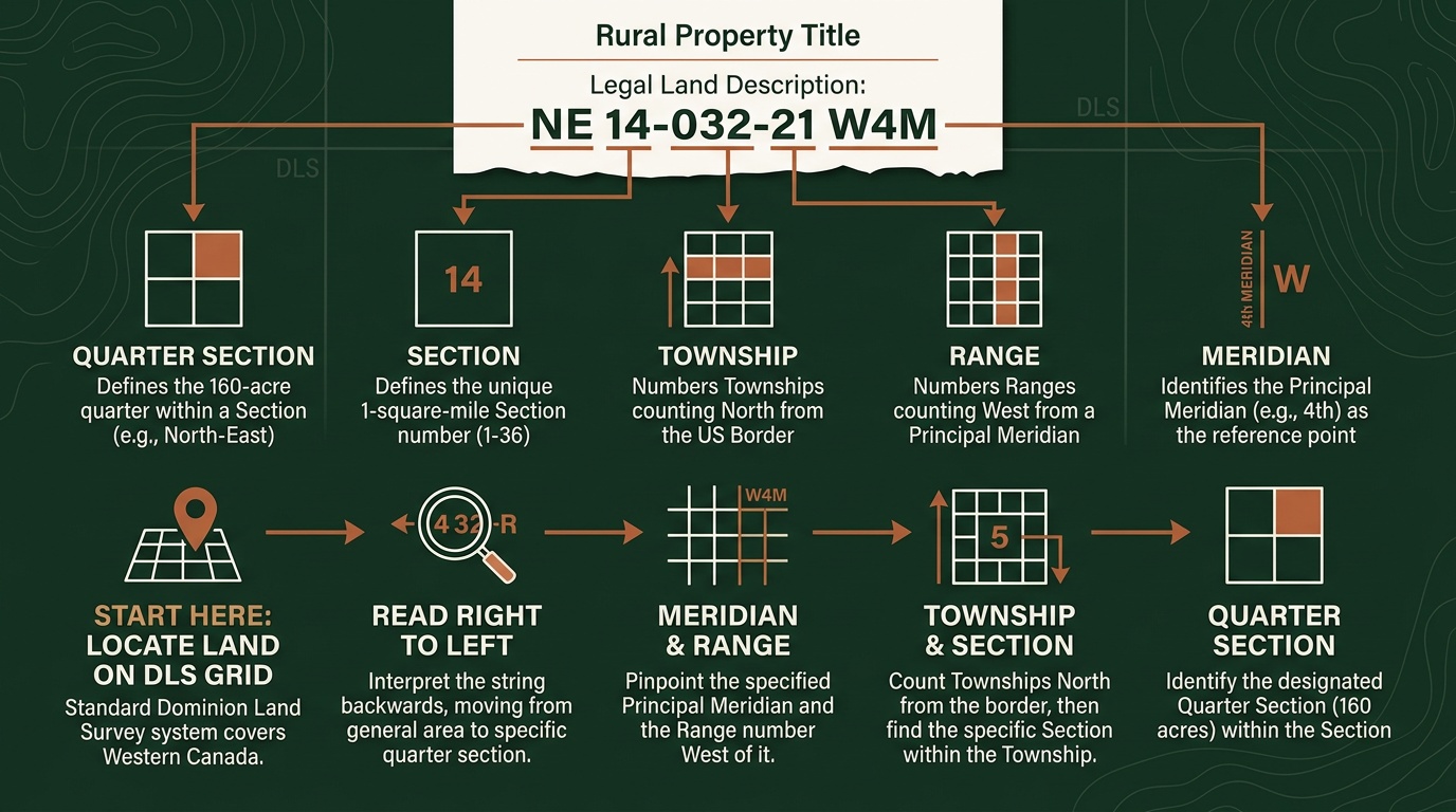
Let's work through a real title description: NE 14-032-21 W4M. Read from right to left - start with the largest unit and work inward.
W4M - West of the 4th Meridian The meridian is the vertical reference line. Six principal meridians run north-south across the prairies. W4M (West of the 4th Meridian) covers eastern Alberta, running along the Alberta-Saskatchewan border. W5M covers central Alberta. W6M covers far-western Alberta near the BC border. Saskatchewan primarily uses W2M and W3M.
21 - Range 21 Ranges are columns of townships, numbered westward from the meridian. Range 21 means this land sits 21 columns west of the 4th Meridian.
032 - Township 32 Townships are rows, numbered northward from the US border (the 49th parallel). Township 32 places this property roughly in the Drumheller–Hanna corridor of east-central Alberta.
14 - Section 14 Each township is a 6×6 grid of 36 sections. Each section is one square mile, or 640 acres. Sections are numbered in a serpentine pattern starting from the southeast corner: Section 1 is bottom-right, Section 6 is bottom-left of the first row, Section 7 is directly above Section 6 on the left side of the second row, and so on up to Section 36 in the northeast corner.
NE - Northeast Quarter Each section is divided into four quarter sections: NE (northeast), NW (northwest), SE (southeast), and SW (southwest). Each quarter is approximately 160 acres. NE 14 is the northeast quarter of Section 14.
So NE 14-032-21 W4M is the northeast quarter of Section 14, Township 32, Range 21, West of the 4th Meridian. That's roughly 160 acres of land in the Hanna area of Alberta.
Quarter Sections vs. Legal Subdivisions
Most rural real estate titles reference quarter sections - the 160-acre parcels described above. But you'll occasionally see a different format on titles, especially for smaller parcels or well site leases: the Legal Subdivision, or LSD.
An LSD description looks like this: LSD 06-32-048-07 W5M.
The last four components are the same - Section 32, Township 48, Range 7, West of the 5th Meridian. The difference is the leading number. Instead of a quarter direction (NE, NW, SE, SW), an LSD uses a number from 1 to 16. Each section is divided into 16 legal subdivisions of roughly 40 acres each - four LSDs per quarter section.
LSDs are numbered in the same serpentine pattern as sections within a township. LSD 1 is in the southeast corner of the section, LSD 4 is in the southwest corner of the first row, LSD 5 is directly above LSD 4 on the left side of the second row, and so on.
For rural real estate, the practical difference is size. A quarter section is 160 acres. An LSD is 40 acres. If a title references an LSD, the property is one-quarter the size of a standard quarter section. This matters for acreage calculations, property tax assessments, and purchase price comparisons.
How to Place a Legal Description on a Map
Reading the notation is step one. Step two is knowing where it actually is on the ground - which road to take, what's nearby, and how to direct a buyer or appraiser to the site.
You can type any DLS description into Township Canada's converter and get GPS coordinates, a map pin, and satellite imagery in seconds. Enter NE 14-032-21 W4M and you'll see the parcel outlined on the map east of Hanna, Alberta, with the nearest highways and range roads visible.

This is especially useful when a buyer calls about a listing and wants to drive out to see the land. You can convert the legal land description from the title, get a shareable pin link, and send it to them - no need to try to describe which range road intersection to look for.
For Saskatchewan listings, the same process works. A title reading SW 21-015-20 W2M is the southwest quarter of Section 21, Township 15, Range 20, West of the 2nd Meridian - farmland southeast of Weyburn. Enter it in the Saskatchewan converter and you'll get exact coordinates and a map view.
Sharing a Property Location with Clients
Once you've converted a legal land description to a map location, Township Canada generates a shareable link for the result. You can send this directly to a buyer, appraiser, or mortgage specialist - they get a map pin, GPS coordinates, and the full legal description in one view, without needing to understand the DLS grid themselves.
For agents managing multiple rural listings, the Projects feature lets you save and organize converted locations. Pin all your active listings in one project, and you have a visual map of your rural portfolio you can pull up during client meetings or use with the route planner to schedule property showings efficiently.
Quick Reference: Reading Any Rural Title
Every Alberta and Saskatchewan rural title follows the same pattern. Once you've read a few, the format becomes automatic:
- Quarter Section: Quarter – Section – Township – Range – Meridian (e.g., NE 14-032-21 W4M)
- LSD: LSD Number – Section – Township – Range – Meridian (e.g., LSD 06-32-048-07 W5M)
The quarter or LSD tells you the specific parcel. The section tells you the square mile. The township and range tell you the grid position. The meridian tells you which province and region. Read right to left to zoom in from the broadest reference to the specific parcel.
If you're working a rural transaction and need to confirm a property location, convert a legal land description to GPS coordinates, or send a client a map pin, try the converter - it takes less time than explaining range roads over the phone.