By Township Canada
Manitoba's Two Land Systems: When a Title Has Both a River Lot and a Quarter Section
How to read Manitoba titles that carry both a river lot and a DLS description. A practical guide for real estate agents and conveyancers using a river lot converter for Manitoba properties.
A title search in the Winnipeg–Selkirk corridor returns two distinct legal descriptions for the same property - one referencing a river lot and parish, the other a DLS quarter section. This is not a title defect and it's not uncommon. It's the direct result of how Manitoba's land was surveyed, settled, and then resurveyed over 150 years. Using a river lot converter for Manitoba alongside your DLS tools is part of working through those titles accurately.
This guide covers what each description means, when both appear on a single title, and how to convert either one to GPS coordinates for field verification.
Why Manitoba Has Two Survey Systems
Most of western Canada uses only the Dominion Land Survey (DLS) - the township-range-section grid that governs Alberta, Saskatchewan, and the majority of rural Manitoba. But Manitoba's agricultural heartland along the Red and Assiniboine rivers was already occupied and surveyed before the DLS reached the province.
The Red River Settlement, established in 1812, divided land into long narrow strips running perpendicular from the riverbank - a system modelled on the French seigneurial long-lot tradition. Every settler received river frontage; every lot was identified by a number within a named parish. By the time Manitoba entered Confederation in 1870, hundreds of these river lot grants were in place, protected under the Manitoba Act.
When the Dominion Land Survey arrived in 1871, it laid a new rectangular grid over territory where many parcels already had legal descriptions. Both systems became valid simultaneously, and both remain valid today. Manitoba is the only western province where this overlap exists at any significant scale.
Reading a River Lot Description
River lot descriptions follow a consistent format:
River Lot number, Parish of name
For example: River Lot 52, Parish of St. Andrews
St. Andrews Parish runs along the west bank of the Red River north of Winnipeg, in what is now the RM of Rockwood. Lot 52 is a strip of land running from the riverbank back into agricultural territory north of the city.
Two elements are mandatory: the lot number and the full parish name. A river lot number without a parish name is not a legal description - every parish along both rivers has its own lot sequence, and each lot number refers to different ground in each parish. The description must specify the parish.
Parish names in the Winnipeg corridor include St. Andrews, St. Clements, Kildonan, St. Norbert, St. Vital, St. Boniface (east bank of the Red River), Headingley, and St. François Xavier along the Assiniboine.
Subdivided lots add a directional qualifier: The South Half of River Lot 18, Parish of St. Clements, or The East Half of River Lot 7, Parish of St. Johns.
Standard lot dimensions were approximately 10 chains wide at the river and two miles deep - roughly 160 acres in total, coincidentally the same area as a DLS quarter section, but a completely different shape: long and narrow rather than square. The River Lots system overview covers the parish structure, lot dimensions, and historical numbering conventions in full.
Reading a DLS Description
The DLS description identifies a parcel by quarter section, section, township, range, and meridian. In Manitoba, the primary reference line is the 1st Meridian (W1), running through southeastern Manitoba at approximately 97°20'W.
A typical Manitoba DLS description: NW 12-008-04W1
Reading left to right, as DLS descriptions are structured:
- NW - northwest quarter
- 12 - section 12
- 008 - township 8
- 04 - range 4 west of the meridian
- W1 - west of the 1st Meridian
This parcel is near Sanford, Manitoba, at approximately 49.50°N, 97.79°W. It's one of millions of acres of Manitoba farmland described using the DLS grid.
The DLS system guide covers the grid structure in full. For Manitoba specifically, the Manitoba legal land description guide explains how the 1st Meridian works and includes a DLS coordinate reference table for locations across the province.
When Both Appear on the Same Title
In the overlap zone - the parishes immediately surrounding Winnipeg and the river corridors extending north to Selkirk and west to Portage la Prairie - a single property can legally carry both descriptions. There are three main reasons this happens:
The river lot predates the DLS. When the 1871 survey overlaid the DLS grid on existing river lot territory, the two systems intersected rather than replacing each other. A property with a river lot grant from 1865 received a DLS coordinate by default when the grid survey mapped it. Both descriptions now identify the same parcel from different frameworks.
Successive title fragmentation. Many river lots near Winnipeg have been subdivided, consolidated, and re-registered multiple times since the 1880s. A title may reference the original river lot as the root of title, then use a DLS reference to identify the specific carved-out portion conveyed in a later transaction.
Corridor rights-of-way. Manitoba Hydro transmission lines and provincial highway rights-of-way often traverse both systems within the same registered easement document. A corridor that begins in DLS quarter-section territory may cross into river lot territory within the same boundary description. Planners working on the Winnipeg–Brandon corridor routinely encounter mixed-system right-of-way tables.
When both appear on a title, treat the river lot description as the historical root of title and the DLS reference as the current administrative identifier. They don't contradict each other - they describe overlapping ground from two different survey frameworks.
Converting Both Descriptions for Field Work
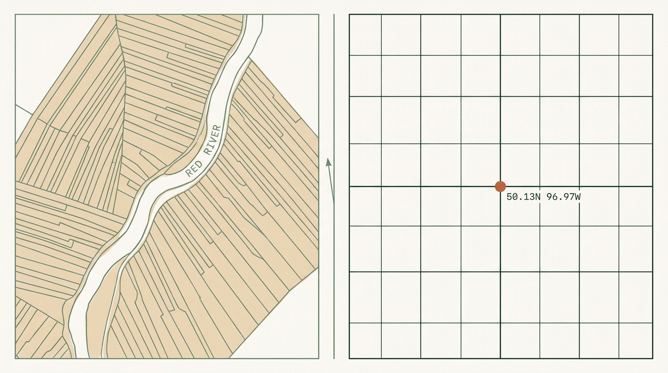
For site visits, boundary verification, or corridor planning, you need GPS coordinates for both descriptions. A basic DLS converter won't handle river lot format; a tool built only for river lots won't handle DLS. You need both in one place.
The Manitoba legal land converter handles both systems. Enter a river lot like River Lot 91, Parish of St. Andrews and the map locates the lot along the Red River north of Winnipeg. Enter NW 12-008-04W1 and it shows the quarter section near Sanford. The converter returns GPS coordinates and renders the approximate parcel boundary on the map for each description.
For a step-by-step walkthrough, the river lot converter for Manitoba guide covers the lookup process for parish lots and explains the output format.
For properties in the overlap zone, running both descriptions through the converter and comparing their map positions is a practical way to confirm that the DLS reference is actually describing the same ground as the river lot root of title - and that there's no meridian or range transcription error placing the DLS result somewhere else.

For bulk processing - a stack of mixed-description titles, a corridor right-of-way table, or a drainage district inventory with both systems - the batch converter handles both DLS and river lot formats in the same CSV upload (Business tier).
What to Watch For
Parish misidentification is the most common error. Using a modern municipal name ("RM of Rockwood") instead of the historical parish name ("St. Andrews") won't return results. The description must use the historical parish name as it appears in the original grant.
Bank orientation matters in parishes that appear on both sides of a river. St. Boniface river lots are on the east bank of the Red River; properties on the west bank near the same area fall under different parish names. If a lot lookup returns coordinates that don't match the expected location, confirm the bank assignment.
Subdivision fragmentation: many river lots near Winnipeg have been subdivided into dozens of parcels over the past century. A title referencing The South Half of River Lot 18, Parish of St. Clements describes a portion of the original lot, not the full extent. The GPS coordinates returned reflect the half-lot area.
Hay privilege descriptions: some historical Manitoba land records include "hay privilege" lots - additional strips extending two to three miles beyond the standard river lot depth. These look similar to standard river lot grants but describe different land further from the river. Confirming which type of description you have requires reading the full grant document.
For legal boundary determinations, the Manitoba Land Titles Office is the authoritative source. GPS coordinates from a converter are accurate for field orientation and administrative planning - the starting point for a site visit, not a substitute for a registered survey.
Working Through Mixed Titles
The dual-description property is a feature of Manitoba's settlement history, not a title anomaly to work around. Real estate agents, conveyancers, and corridor planners in the Winnipeg metropolitan fringe encounter these descriptions regularly and need tools that handle both.
The Manitoba legal land converter and the River Lots system overview are the two resources that cover this ground in the most depth. Both systems are supported in the same converter - enter either format and get GPS coordinates and a map position in return.