By Township Canada
BC NTS Grid References: How to Read Them and Convert to GPS for Field Work
Learn how to read BC NTS grid references and convert them to GPS coordinates. A practical guide for surveyors, mining crews, and forestry teams in British Columbia.
BC NTS Grid References: How to Read Them and Convert to GPS for Field Work
You're heading into the field north of Prince George with a stack of mineral claim documents, and every location is written as something like 094G/04. No latitude, no longitude - just an alphanumeric code that references a paper map series from the 1950s. If you can't convert that BC NTS grid reference to GPS coordinates your crew can actually use, you're navigating blind.
British Columbia's resource industries - mining, forestry, oil and gas - rely on the National Topographic System (NTS) to describe locations across the province's rugged terrain. Unlike the Dominion Land Survey grid that covers Alberta and Saskatchewan's prairies, the NTS was built for mountainous country where rectangular sections don't fit. If you work with BC land records, mineral claims, or forestry tenure, reading NTS references is a daily task.
Here's how the system works, what each part of an NTS reference means, and how to get GPS coordinates from any NTS code in seconds.
Why BC Uses NTS Instead of DLS
The prairies were surveyed in the 1870s–1880s under the Dominion Land Survey, which divides land into a neat grid of townships, sections, and quarter sections. That system assumes flat terrain where surveyors can run straight lines across the landscape.
British Columbia's Coast Mountains, Rocky Mountains, and deeply carved river valleys made that approach impractical. Instead, the federal government mapped BC using the National Topographic System - a hierarchy of map sheets originally produced for the 1:50,000 and 1:250,000 national mapping program. Over time, NTS map sheet references became the standard way to describe locations for mining claims, forestry cutblocks, and Crown land applications across most of the province.
The one exception: BC's Peace River region in the northeast (around Fort St. John and Dawson Creek) was flat enough to survey under DLS, so it uses the same township-range-meridian system as Alberta.
How to Read a BC NTS Grid Reference
An NTS reference is a nested address. Each level subdivides the level above it, zooming in from a continent-scale map area down to a parcel small enough for field work.
The Three Main Scale Levels
1. Map Series (1:1,000,000) - The broadest level. A two- or three-digit number identifying a large block of the country. BC falls mainly within series 082 through 104. Series 094, for example, covers a wide area of northeastern BC including the Liard Basin and parts of the Rocky Mountain Foothills.
2. Map Area (1:250,000) - Each series divides into 16 lettered areas (A through P, skipping I and O). Adding the letter narrows the location significantly. 094G identifies a specific 1:250,000 map area within series 094 - north of Prince George, in the McGregor Plateau region.
3. Map Sheet (1:50,000) - Each area divides into 16 numbered sheets (01 through 16). These correspond to the standard 1:50,000 topographic maps published by Natural Resources Canada. 094G/04 pinpoints a single map sheet - roughly 30 km across - within area 094G.
Below the Sheet: Blocks, Units, and Quarter Units
For finer precision, NTS goes deeper:
- Block (A through L) - Each sheet divides into 12 blocks
- Unit (1 through 100) - Each block contains a 10×10 grid of units
- Quarter Unit (A, B, C, D) - Each unit splits into four quarters (SW, SE, NE, NW)
A full NTS reference might look like A-2-F/93-P-8 - Quarter Unit A, Unit 2, Block F, within map sheet 93-P-8. That's specific enough to locate a drill site or a cutblock boundary.
For a detailed breakdown of every NTS level, see the BC NTS grid explained guide.
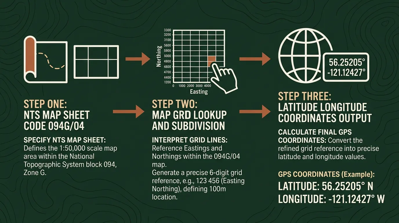
Converting a BC NTS Grid Reference to GPS Coordinates
Let's walk through a real conversion using 094G/04 - a map sheet reference north of Prince George in central BC.
Step 1: Open the BC NTS converter and type 094G/04 into the search bar.
Step 2: Review the result. The converter returns the centre-point GPS coordinates for that map sheet and shows the sheet boundary on the map. You'll see the sheet placed in context within the broader 094G area.

Step 3: Export or navigate. Copy the coordinates directly for your GPS device, or export to KML for use in GIS software. If you need turn-by-turn directions to the sheet centre from your current location, the directions feature handles that too.
Step 4: For higher precision, add the block, unit, and quarter unit. Enter A-2-F/094-G-04 to drill down to a specific quarter unit within that sheet. The map zooms in and the coordinates narrow to a much smaller area - useful for locating a specific mineral claim cell or a cutblock.
For batch work - converting dozens of NTS references from a tenure database or field report - upload a CSV through the batch conversion tool and get GPS coordinates for every row at once.
Where BC NTS References Show Up in Practice
Mining claims on BC Mineral Titles Online. When you stake a mineral claim in BC, the system requires NTS map sheet references. A prospector targeting copper-gold in the Golden Triangle files claims referencing sheets within the 104 series. Converting those references to GPS is how the field crew actually finds the ground. See the mining industry guide for more on how NTS fits into the full claim lifecycle.
Forestry tenure and cutblock planning. BC's forest tenure system - timber supply areas, tree farm licences, community forest agreements - uses NTS references to define management boundaries. A logging planner working in the Prince George Timber Supply Area needs to convert NTS block references to GPS coordinates for road layout and harvest planning.
Northeast BC oil and gas. The Montney and Liard formations straddle both NTS and DLS territory. A landman working the BC side of the Montney outside the Peace River DLS block encounters NTS references for well licences issued by the BC Energy Regulator. For a full picture of how BC's NTS system intersects with the province's resource tenure, see the British Columbia legal land description guide.
Pipeline corridor surveys. Linear infrastructure projects - pipelines, transmission lines, highways - crossing NTS territory need GPS coordinates for every crossing point, valve station, and environmental monitoring location along the route.
Common Mistakes Reading BC NTS References
Confusing the 1:250,000 area with the 1:50,000 sheet. 094G is a map area covering thousands of square kilometres. 094G/04 is a specific sheet within it. Citing just 094G when you mean a specific sheet leaves your location vague by a factor of 16.
Misreading the alphanumeric sheet identifier. The letters within an NTS area run in a serpentine pattern, not straight alphabetical order. Sheet A is at the southeast, and the pattern reverses direction on each row heading north. Assuming alphabetical left-to-right order will land you in the wrong part of the area.
Mixing up NTS and DLS in northeast BC. The Peace River region uses both systems. If your reference includes a township, range, and meridian (like Twp 84 Rge 14 W6M), that's DLS - use a DLS converter instead. If it has a series number and letter code, it's NTS.
Dropping precision levels. A sheet-level reference (094G/04) covers roughly 900 square kilometres. For field navigation, you typically need the block and unit as well. Always check whether the source document includes sub-sheet precision before heading into the field with only a sheet-level coordinate.
From Grid Reference to GPS in Seconds
BC's NTS system is well designed for what it was built to do: organize a massive, mountainous province into a consistent reference grid. The challenge is that GPS devices, mobile apps, and GIS software all speak in latitude and longitude - not map sheet codes.
Township Canada's BC NTS converter bridges that gap. Enter any NTS reference - from a broad map area down to a specific quarter unit - and get the GPS coordinates, a boundary polygon on the map, and export options for your field tools. For teams processing large NTS datasets, the batch converter handles CSV uploads with thousands of references in a single pass.
Try it with 094G/04 - paste the reference into the converter and see where it lands on the map.
If you also need to see property boundaries alongside your NTS references, Township Canada now shows ParcelMap BC parcel boundaries as a toggleable map layer - NTS grid and property lines in one view.